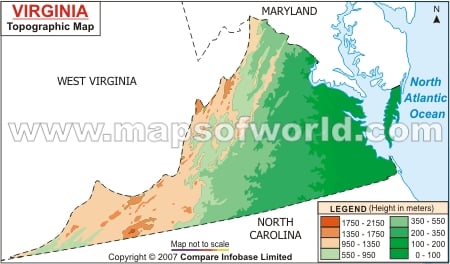
Virginia Topographic Map indicates the physiographic features of the state.
The Allegheny Mountains of Appalachian Chain and Blue Ridge, the Piedmont Plateau and the Atlantic Coastal Plain are the three prime elements of the topography of Virginia. While the Blue Ridge and Allegheny Mountains lie on northwest and western parts of the state, Piedmont Plateau forms the central portion of Virginia. The Allegheny Mountains have an average height of 900 m. The highest point of Virginia with a hight of 1747 m is at Mount Rogers which has evolved from Blue Ridge. Having six valleys and transverse ridges, the valley of Virginia is located between the Allegheny Mountains belonging to the Appalachian Chain and the Blue Ridge. The Tide water or Atlantic Coastal Plain is intersected by such rivers of the state as Rappahannnock, James, Potomac and York. The Chesapeake Bay is also known to cut the Atlantic Coastal Plain of Virginia state. Hampton Roads estuary is one of the major harbors of the Tidewater of Virginia. The Piedmont Plateau extends up to 290 km towards the south of Virginia, while it is 64 km long in the northern parts of the state. The Virginia state map offers comprehensive overview of the topography of the place.
