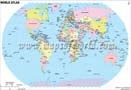
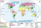
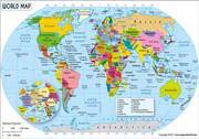
World Map HD
Explore the World Map HD to know the location of all countries in the world with political boundaries. This high-resolution world map (created by using the Mercator projection) shows each country in a different color. World Map HD is a large map of 27.77 inches x 20.48 inches dimension, bold colors, user-friendly fonts, and clear cartography. This HD world map is available in multifarious formats: AI, EPS, JPEG, or layered PDF. Whether you are looking for a printable or customized world map with countries, international boundaries, country names, and many other features, you’ll find everything at MapOfWorld.com.
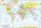
Click on any Country for its Map & Information ( Download Free World Map in PDF)


| Description : This large world map (27.77 inches x 20.48 inches) has clear cartography, bold colors, and user-friendly fonts. The image is a high-resolution world map, and available in AI, EPS, JPEG, or layered PDF formats. The map is customizable. Please contact us if you have any questions. |
×
Disclaimer : All efforts have been made to make this image accurate. However MapSherpa, Inc, its directors and employees do not own any responsibility for the correctness or authenticity of the same.

 Copyright © 2023 mapsofworld.com. All Rights Reserved.