- Virginia Counties - Virginia County Map, Map of Virginia Counties
- Major Cities of Virginia - Portsmouth, Richmond VA, Salem, Bedford, Bristol
- Neighbouring States - Kentucky, West Virginia, Maryland, North Carolina, Tennessee
- Regional Maps - Map of USA
- Other Virginia Maps - Virginia Map, Where is Virginia, Virginia Airports Map, Virginia Lat Long Map, Virginia Zip Code Map, Virginia Area Code Map, Virginia National Parks Map
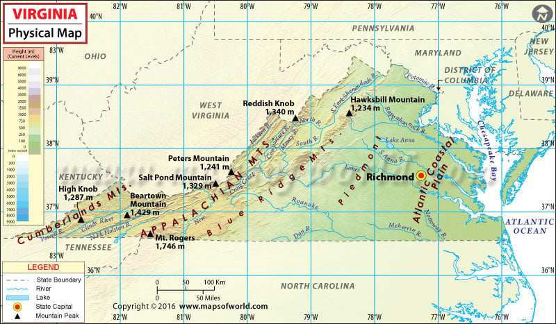
Virginia Physical Map
The Blue Ridge Mountains and the Chesapeake Bay dictate geography and climate of the Commonwealth of Virginia. The state of Virginia is divided into five physical regions (east to west): Tidewater, Piedmont, Blue Ridge Mountains, Ridge and Valley, and the Cumberland Plateau.
The Tidewater region is a coastal plain that stretches between the Atlantic coast and the Fall line in eastern Virginia. It features the Eastern Shore and estuaries of Chesapeake Bay. The region is generally low-lying and features tidal marsh and swamps. Hampton Roads is considered to be a part of this coastal region.
The Piedmont plateau is a series of rock-based foothills that are bounded by the Blue Ridge Mountains in the west and the Fall line in the east. In terms of area, it is the largest physical feature in Virginia.
The easternmost range of the Appalachians, the Blue Ridge Mountains are home to some of the highest elevations in the state. The highest peak in Virginia is Mount Rogers at 1,746 meters. These mountains extend southwards to North Carolina.
The Ridge and Valley region lies west of the mountains. The terrain is a mix of rolling hills and valleys.
The Cumberland Plateau and the Cumberland Mountains, south of the Allegheny Plateau, cover the far southwest corner of the state.
Many of Virginia’s rivers empty into the Chesapeake Bay, including the Potomac, Rappahannock, and York. The 150-mile-long Shenandoah River Valley is located between the Blue Ridge and the Allegheny Mountains. With an area of 13,000 acres, Lake Anna is one of the largest freshwater inland lakes in the state.
 Wall Maps