- Pennsylvania Counties - Pennsylvania County Map, Map of Pennsylvania Counties
- Major Cities of Pennsylvania - Philadelphia, Lancaster
- Neighbouring States - New York, Ohio, Maryland, Delaware, New Jersey, West Virginia
- Regional Maps - Map of USA
- Other Pennsylvania Maps - Pennsylvania Map, Where is Pennsylvania, Pennsylvania Airports Map, Pennsylavania Lat Long Map, Pennsylvania Zip Code Map, Pennsylvania Area Code Map, Pennsylvania National Parks Map
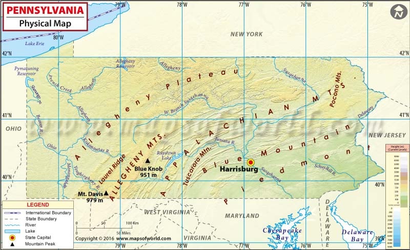
Pennsylvania Physical Map
Pennsylvania is aptly nicknamed the ‘Keystone State’ as it forms a land bridge between the Northeastern and the Southern states, and between the East Coast and the Midwest.
Eastern Pennsylvania lies in the Piedmont region of the Appalachians. The region features rolling, wooded hills, deep river valleys, and fertile soils. The Delaware River defines the eastern boundaries of the state. The Susquehanna River provides a drainage system. The Pennsylvania Dutch Country is a sub-region of Eastern Pennsylvania. To the southeast of the plateau region, the Ridge-and-Valley Appalachians cover the region. These ridge-and-valley formations contain the richest deposits of clean-burning anthracite coal in the world. Northeastern Pennsylvania also features Pocono Mountains, Endless Mountains, and Wyoming Valley.
In the central region, the Appalachian Mountains bisect the state with an S-shaped curve by the barrier ridges. The 47-mile-long Pine Creek Gorge or the Grand Canyon of Pennsylvania lies in the region. The Allegheny Plateau is an interminable series of highlands and dramatic valleys.
Western Pennsylvania is known for having a distinct topographical and cultural separation from the east by virtue of the Appalachians. Mount Davis in Laurel Highlands, the highest point in Pennsylvania, stands at 3,213 feet (979 meters). The Allegheny River and Monongahela River are major watersheds in the area. Comprising an area of over 500,000 acres, Allegheny National Forest is located in northwestern Pennsylvania. Much of the northwestern state features orchards and vineyards along the Lake Erie shoreline.
 Wall Maps