- Pennsylvania Counties - Pennsylvania County Map, Map of Pennsylvania Counties
- Major Cities of Pennsylvania - Philadelphia, Lancaster
- Neighbouring States - New York, Ohio, Maryland, Delaware, New Jersey, West Virginia
- Regional Maps - Map of USA
- Other Pennsylvania Maps - Pennsylvania Map, Where is Pennsylvania, Pennsylvania Physical Map, Pennsylavania Lat Long Map, Pennsylvania Zip Code Map, Pennsylvania Area Code Map, Pennsylvania National Parks Map
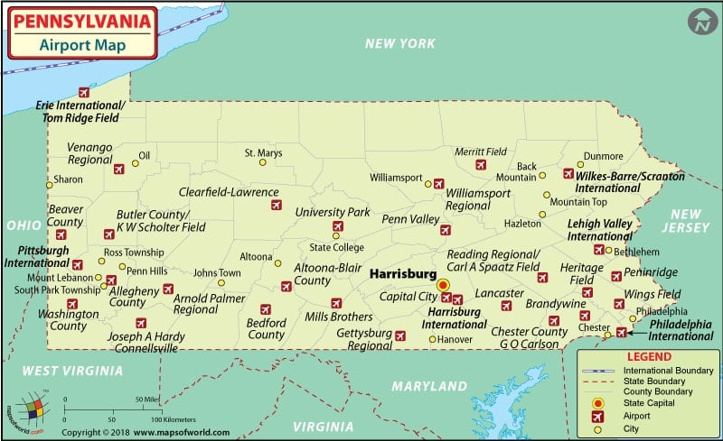
Airports in Pennsylvania
The international airports in Pennsylvania are Lehigh International Airport at Allentown, Erie International Airport at Erie, Harrisburg International Airport at Harrisburg, Philadelphia International Airport at Philadelphia, Pittsburgh International Airport at Pittsburgh, and Wilkes-Barre/Scranton International Airport at Wilkes-Barre.
The Pittsburgh International Airport receives more than ten million passengers annually and has been ranked as being amongst the top three airports in the world in terms of its excellent customer oriented services. The airport has many retail stores selling various goods, and there are also numerous eateries, news and gifts shops, ATMs and foreign currency exchange for customer’s entertainment and convenience. The airport is disabled-friendly, and also has a train facility available to make travel easy from one concourse to another.
Some of the 50 airlines serving at this airport are Northwest Airlines, Midwest Airlines, Air Canada, Delta Airlines, American Airlines, Southwest Airlines, JetBlue Airlines, Continental Airlines, United Airlines, Air tran Airways, and USA 3000.
The Philadelphia International Airport is the 9th busiest airport in the world. The Philadelphia Marketplace Food, Shops and services at the airport have a mind-boggling number of eateries, retail stores that sell everything that one can think of, and a number of newsstands.
There are almost 50 airlines serving this airport, including: American Airlines, Cathay Pacific, Air France, Air India, Lufthansa, KLM, Korean Air, Japan Airlines, Thai Air, British Airways, Kiwi Airlines, Lacsa, Pro Air Inc., Kenya Air, Eastwind Airlines Inc., Swissair, TACA, Singapore Airlines, Air Jam and South African Airlines.
One can book the tickets of the aforementioned airlines online. Some of the airlines also offer special fares and discounts for booking tickets online.
The most important airports in Pennsylvania are at Bradford, Meadville, Franklin, Du Boise, Stroudsburg, Hazelton, Reading, Lancaster, Gettysburg, Harrisburg, Altoona, Johnstown, Indiana, and Butler.
Locations in the Map
Harrisburg, Altoona, Johnstown, Pittsburgh, Williamsport, Scranton.
Bradford, Meadville, Franklin, Du Boise, Stroudsburg, Hazelton, Allentown, Reading, Lancaster, Gettysburg, Harrisburg, Altoona, Johnstown, Indiana, Butler, Pittsburgh.
Meadville, Allentown, Union City, Warren, Kane Emporium, St. Marys, Williamsport, Benwick, Scranton, Towanda, Mansfield, Wellsboro, Carbondale, Stroundsburg, Hazelton, Betblehem, Oil City, Merser, Brookville, Clearfield, Bottsville, Allentown, Indiana, Pittsburgh, Wheeling, Somerset, Waynesburg, Johnstown, Carlisle, York, Lancaster, Hershey, Gettysburg.
Maps of Major Airports in Pennsylvania
- Erie International Airport Map
- Harrisburg International Airport Map
- Philadelphia International Airport Map
- Pittsburgh International Airport Map
- Wilkes Barre/Scranton International Airport Map
List of Airports in Pennsylvania |
|---|
| Airport Name | City | Coordinates |
|---|---|---|
| Lehigh Valley International Airport | Lehigh Valley | 40°39′08.4″N 075°26′25.7″W |
| Erie International Airport | Millcreek Township, Erie | 42°04′55″N 80°10′34″W |
| Harrisburg International Airport | Harrisburg | 40°11′35″N 076°45′48″W |
| Arnold Palmer Regional Airport | Latrobe | 40°16′29″N 079°24′24″W |
| Philadelphia International Airport | Delaware Valley | 39°52′19″N 075°14′28″W |
| Pittsburgh International Airport | Pittsburgh | 40°29′29″N 080°13′58″W |
| University Park Airport | State College | 40°50′57″N 77°50′55″W |
| Wilkes-Barre/Scranton International Airport | Wilkes-Barre/Scranton | 41°20′18″N 075°43′24″W |
| Williamsport Regional Airport | Williamsport | 41°14′30″N 076°55′18″W |
| Altoona-Blair County Airport | Altoona | 40°17′47″N 078°19′12″W |
| DuBois Regional Airport | DuBois, Clearfield County | 41°10′42″N 078°53′55″W |
| John Murtha Johnstown-Cambria County Airport | Johnstown | 40°18′56″N 078°50′05″W |
| Bradford Regional Airport | Bradford | 41°48′11″N 078°38′24″W |
| Venango Regional Airport | Franklin | 41°22′40″N 079°51′37″W |
| Lancaster Airport | Lancaster | 40°07′20″N 076°17′40″W |
| Butter Valley Golf Port | Bally | 40.398056, -75.564444 |
| Grimes Airport | Bethel | 40°29′05″N 076°15′49″W |
| Perkiomen Valley Airport | Collegeville | 40°12′15″N 075°25′49″W |
| Rocky Hill Ultralight Flightpark | Cresco | 41°08′52″N 075°16′30″W |
| Danville Airport | Danville | 40°57′05″N 076°38′34″W |
| Stroudsburg-Pocono Airport | East Stroudsburg | 41°02′09″N 075°09′38″W |
| Braden Airpark | Easton | 40°44′31″N 75°14′34″W |
| Van Sant Airport | Erwinna | 40°29′03″N 075°05′59″W |
| Philadelphia Seaplane Base | Essington | 39°51′38″N 75°18′00″W |
| Farmers Pride Airport | Fredericksburg | 40°26′34.33″N 076°26′29.86″W |
| Cherry Ridge Airport | Honesdale | 41°30′56″N 075°15′06″W |
| Greensburg Jeannette Regional Airport | Jeannette | 40°22′35″N 079°36′32″W |
| Keller Brothers Airport | Lebanon | 40°17′29.5″N 076°19′43.5″W |
| Lakehill Airport | Mars | 40°42′25″N 080°01′49″W |
| Pittsburgh-Monroeville Airport | Monroeville | 40°27′08″N 079°46′29″W |
| Husky Haven Airport | Montrose | 41°47′20″N 075°53′24″W |
| Mount Pleasant/Scottdale Airport | Mount Pleasant | 40°06′30″N 079°32′29″W |
| Deck Airport | Myerstown | 40°21′07.66″N 076°19′46.72″W |
| Reigle Field | Palmyra | 40°17′12″N 076°34′37″W |
| Pennridge Airport | Perkasie | 40°23′21″N 075°17′26″W |
| Albert Airport | Philipsburg | 49°58′12″N 002°41′33″E |
| Rock Airport | Pittsburgh / Tarentum | 40°36′13″N 079°49′34″W |
| Smoketown Airport | Smoketown / Lancaster | 40°02′28″N 76°12′05″W |
| Bendigo Airport | Tower City | 40°33′31″N 076°33′34″W |
| Skyhaven Airport | Tunkhannock | 41°31′45″N 075°56′49″W |
| Ridge Soaring Gliderport | Unionville / Julian | 40°53′02″N 077°54′26″W |
| Greene County Airport | Waynesburg | 39°54′04″N 080°07′50″W |
| York Airport | York / Thomasville | 39°55′01″N 076°52′23″W |
 Wall Maps