- Maryland Counties - Maryland County Map, Map of Maryland Counties
- Major Cities of Maryland - Frederick, Annapolis, Baltimore
- Neighbouring States - Pennsylvania, Delaware, Virginia, West Virginia
- Regional Maps - Map of USA
- Other Maryland Maps - Maryland Map, Where is Maryland, Maryland Physical Map, Maryland Lat Long Map, Maryland Zip Code Map, Maryland Area Code Map, Maryland Narional Parks Map
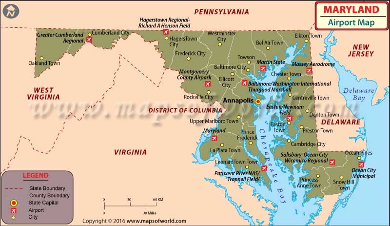
Two major airports in Maryland are Hagerstown Regional Airport and the Salisbury-Ocean City Wicomico International Airport.
The Hagerstown Regional Airport offers free parking, free WiFi, less than an hour’s check-in time, and accessibility for people with disabilities.
The Maryland airport is also connected to the Pittsburgh International Airport. One of the major airlines operating at this airport is US Airways.
The other important airports in Maryland are in Baltimore, Washington, D.C., and Annapolis.
Here’s a look at other prominent airports in Marryland:
-
-
Tipton Airport
-
As a public airport, the Tipton Airport is located just south of Fort George G. Meade in Odenton, Anne Arundel County, Marryland. Opened in 1999, the airport is bordered by Fort Meade, the Patuxent Wildlife Center and the National Security Agency. The Tipton Airport is being operated by the Tipton Airport Authority.
-
-
College Park Airport
-
As a public airport located in the City of College Park, in Prince George’s County, Marryland, the College Park Airport is the world’s continuously operated airport. It is located south of Paint Branch and Lake Artemesia, east of US Route 1 and the west of Kenilworth Avenue and the College Park Metro/MARC station.
-
-
Bay Bridge Airport
-
Bay Bridge Airport is a county-owned public-use airport. It is located in Stevensille, Maryland and has been named after the nearby Chesapeake Bay Bridge. The airport is mostly used for general aviation. Previously, the airport was also home to Lynn Aviation, the firm owned by aerobatic pilot Nancy Lynn.
-
-
Lee Airport
-
As a public use airport, the Lee Airport is located in Anne Arundel County, Marryland, United States. It is about five nautical miles southwest of the central business district of Annapolis and is privately owned by the Lee Airport Authority in Edgewater, Marryland. The airport covers an area of 79 acres at an elevation of 34 feet above mean sea level.
-
-
Philips Army Airfield
-
As a military airport, Philips Army Airfield is located at Aberdeen Proving Ground in Harford County, Maryland, United States. This is a US Army airfield which has three asphalt paved runways.
-
-
Martin State Airport
-
This is a joint civil-military public use airport, which is located about nine nautical miles east of central business district of Baltimore, in the Baltimore County, Maryland. The airport is being operated by the Maryland Aviation Administration on behalf of the Maryland Department of Transportation. All in all, Martin State Airport is a general aviation relief airport.
Maps of Major Airports in Maryland
- Martin State Airport Map
- Tipton Airport Map
- College Park Airport Map
- Bay Bridge Airport Map
- Lee Airport Map
List of Airports in Maryland |
|---|
| Airport Name | Code | City | Hub | Enplanements (2015) |
|---|---|---|---|---|
| Baltimore/Washington International Thurgood Marshall | BWI | Glen Burnie | L | 11,738,845 |
| Salisbury-Ocean City Wicomico Regional | SBY | Salisbury | N | 61,782 |
| Hagerstown Regional-Richard A Henson Field | HGR | Hagerstown | N | 25,356 |
| Joint Base Andrews | ADW | Camp Springs | None | 2,563 |
| Patuxent River NAS/Trapnell Field/ | NHK | Patuxent River Naval Air Test Center | None | 119 |
| Montgomery County Airpark | GAI | Gaithersburg | None | 21 |
| Easton/Newnam Field | ESN | Easton | None | 19 |
| Martin State | MTN | Middle River | None | 16 |
| Greater Cumberland Regional | CBE | Wiley Ford | None | 15 |
| Maryland | 2W5 | Indian Head | None | 7 |
| Massey Aerodrome | MD1 | Massey | None | 7 |
| Ocean City Municipal | OXB | Ocean City | None | 4 |
 Wall Maps