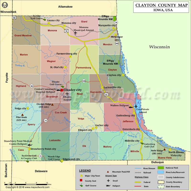
Mountain Peaks in Clayton County
| Mountain Peak/Hill | Elevation [Meter] |
|---|---|
| Chicken Ridge | 355 |
| Hefel Ridge | 281 |
| Pilot Knob | 329 |
More Maps of Clayton County
Airports in Clayton County
| Airport Name |
|---|
| Central Community Hospital Heliport |
| Elkader Airport |
| Gaa Private Airport |
| Monona Municipal Airport |
| Strawberry Point Medical Center Heliport |
| Walters Heliport |
Cities in Clayton County
| City | Population | Latitude | Longitude |
|---|---|---|---|
| Clayton city | 43 | 42.903315 | -91.150574 |
| Edgewood city | 864 | 42.644235 | -91.401734 |
| Elkader city | 1273 | 42.857579 | -91.402359 |
| Elkport city | 37 | 42.741574 | -91.27494 |
| Farmersburg city | 302 | 42.958867 | -91.367069 |
| Garber city | 88 | 42.744429 | -91.261817 |
| Garnavillo city | 745 | 42.866131 | -91.23641 |
| Guttenberg city | 1919 | 42.788713 | -91.105905 |
| Luana city | 269 | 43.059452 | -91.455718 |
| Marquette city | 375 | 43.044601 | -91.190565 |
| McGregor city | 871 | 43.024413 | -91.182094 |
| Millville city | 30 | 42.70364 | -91.076388 |
| Monona city | 1549 | 43.051273 | -91.391204 |
| North Buena Vista city | 121 | 42.677621 | -90.958506 |
| Osterdock city | 59 | 42.731386 | -91.157834 |
| St. Olaf city | 108 | 42.926902 | -91.38789 |
| Strawberry Point city | 1279 | 42.680339 | -91.534957 |
| Volga city | 208 | 42.802667 | -91.542274 |
Golf Courses in Clayton County
| Name of Golf Course | Latitude | Longitude |
|---|---|---|
| Backbone Golf & Country Club-Strawberry Point | 42.644082 | -91.54372 |
| Elkader Golf Course-Elkader | 42.870054 | -91.399987 |
| Guttenberg Golf Club-Guttenburg | 42.698615 | -91.073628 |
| Tri City Golf Course-Luana | 43.071742 | -91.473985 |
| Woods Edge Golf Course-Edgewood | 42.644528 | -91.404879 |
National Parks in Clayton County
| Name of Park | Latitude | Longitude |
|---|---|---|
| Effigy Mounds NM | 43.086407 | -91.187252 |
| Effigy Mounds NM | 42.940467 | -91.167964 |
 Wall Maps