logo


USA Interstate 35 Map
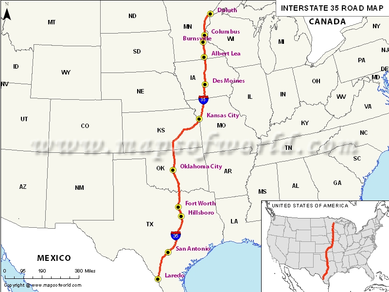

USA Interstate 35 Map
Description:Map depicts US Interstate 35 (I-35) route from Laredo, Texas to Duluth, Minnesota. Disclaimer
×

Disclaimer  :  All efforts have been made to make this image accurate. However MapSherpa, Inc, its directors and employees do not own any responsibility for the correctness or authenticity of the same.


US Interstate 35 highway Map


Interstate 35, popularly abbreviated as I-35 is a major north-south Interstate US Highway situated in the central United States. Out of the Interstate Highways which had splits or spurs, Interstate 35 is the only one that still has such divisions like N/S/E/W, well before the recent opening of the Interstate 69C, Interstate 69E and Interstate 69W in South Texas.

In two different stretches, via the twin cities, the Interstate 35 splits into Interstate 35E at Dallas and at Saint Paul, Minnesota. Also, the US Interstate Highway splits into Interstate 35W at Fort Worth, Texas and also at Minneapolis.


Extent of I-35 Highway

Interstate 35 stretches from Laredo, Texas on the American-Mexican border to Duluth, Minnesota at Minnesota Highway 61(London Road) and the 26th Avenue East. The southern terminus of Interstate 35 is a traffic signal in Laredo, Texas. Also, towards the north, Interstate 35 terminates in Duluth, Minnesota.

States and cities along I-35 Highway


  • Iowa: Des Moines
  • Kansas: Wichita
  • Minnesota: Duluth, Minneapolis-St. Paul
  • Missouri: Kansas City(MO. –KS.)
  • Oklahoma: Norman, Oklahoma City
  • Pennsylvania: Monessen
  • Texas: Austin, Dallas- Worth-Arlington, Denton-Lewisville, Laredo, San Antonio, Temple, Waco

Restaurants along Interstate-35 Highway


Here is a list of few great restaurants along Interstate-35 Highway:

  • MK Davis Restaurant
  • Rudy’s Seafood
  • Viet-Nam Restaurant
  • Lulus Bakery & Café
  • Armadillos


Attractions along I-35 Highway


Some of the renowned tourist attractions along I-35 Highway include:

  • Fort Snelling State Park
  • Beeds Lake State Park
  • Nine Eagles State Park
  • El Dorado State Park
  • Arcadia Lake Parks


Route of Interstate Highway No.35

StateEntry PointExit PointLength
Texas Laredo, TXGainesville, TX407.195 mi (655.317 km)
Oklahoma Marietta, OKBraman, OK235.96 mi (379.74 km)
Oklahoma-Kansas state lineOklahoma-Kansas state lineKansas-Missouri state line235.53 mi (379.05 km)
Missouri Kansas City, MOEagleville, MO114.74 mi (184.66 km)
Iowa Colfax Township, IAFreeman Township, IA219.225 mi (352.808 km)
Minnesota Hartland Township, MNDuluth, MN220.46 mi (354.80 km)
Total Length  1,569.06 mi (2,525.16 km)


US Interstates Highways Route Map

Interstate 4 MapInterstate 35 MapInterstate 70 MapInterstate 86 Map East
Interstate 5 MapInterstate 37 MapInterstate 72 MapInterstate 86 West Map
Interstate 8 MapInterstate 39 MapInterstate 74 MapInterstate 87 Map
Interstate 10 MapInterstate 40 MapInterstate 75 MapInterstate 88 East Map
Interstate 12 MapInterstate 43 MapInterstate 76 east MapInterstate 88 West Map
Interstate 15 MapInterstate 44 MapInterstate 76 west MapInterstate 89 Map
Interstate 16 MapInterstate 45 MapInterstate 77 MapInterstate 90 Map
Interstate 17 MapInterstate 49 MapInterstate 78 MapInterstate 91 Map
Interstate 19 MapInterstate 55 MapInterstate 79 MapInterstate 93 Map
Interstate 20 MapInterstate 57 MapInterstate 80 MapInterstate 94 Map
Interstate 24 MapInterstate 59 MapInterstate 81 MapInterstate 95 Map
Interstate 25 MapInterstate 64 MapInterstate 82 MapInterstate 96 Map
Interstate 26 MapInterstate 65 MapInterstate 83 MapInterstate 97 Map
Interstate 27 MapInterstate 66 MapInterstate 84 East MapInterstate 99 Map
Interstate 29 MapInterstate 68 MapInterstate 84 West Map 
Interstate 30 MapInterstate 69 MapInterstate 85 Map

Last Updated on: April 15th, 2017