Maps of World
Current, Credible, Consistent
World Map / US Map / Highways / US Interstate 74 Map

US Interstate 74 Map

Print
US Interstate 74 Map
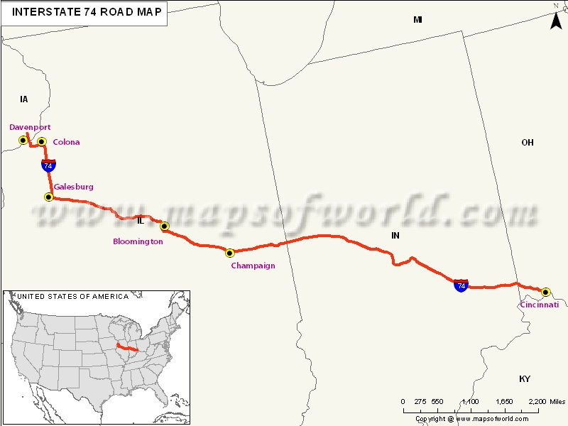
Description : US Interstate 74 (I-74) Map showing routes from Davenport, IA to Cincinnati, Ohio Disclaimer
Close

Disclaimer : All efforts have been made to make this image accurate. However MapSherpa, Inc, its directors and employees do not own any responsibility for the correctness or authenticity of the same.


US Interstate 74 Highway Map


Interstate 74 exists in three areas of North Carolina, which include near Mount Airy; from Interstate 40 at Winston Salem south to Ellerbe; and, between Lumberton and Laurinburg.

Extent of I-74 Highway

I -74 starts from south to Interstate 80. In between, the areas that are covered, include Iowa, Illinois, Indiana, Ohio, North Carolina. In future, there are plans to extend it towards the south and middle-west.

States and Cities Along I-74 Highway


  • Vermillion: Highland Township
  • Fountain: Covington, Veedersburg
  • Montgomery: Wayne Township, Crawfordsville
  • Boone: Jamestone
  • Hendricks: Lizton, Middle Township, Brownsburg
  • Marion: Indianapolis, Wanamaker, Acton, and many more to name.

Restaurants Along Interstate I-74 Highway


  • Buffalo Wild Wings Grill and Bar
  • Thara Thai Restaurant
  • Red Lobster
  • Big Grove Tavern
  • Farren's, etc., to name amongst others.

Attractions Along I-74 Highway


  • Fantasy Balloons
  • Celebration River cruises
  • Quad City Botanical Center
  • Rock Island Arsenal
  • Rock Island County Historical, to name a few.

Route of Interstate Highway No.74

StateEntry PointExit PointLength
Iowa Davenport, IAMississippi River5.386 mi[2] (8.668 km)
Illinois Moline, ILDanville, IL220.34 mi[2] (354.60 km)
Indiana Illinois state lineOhio state line171.54 mi (276.07 km)
OhioIndiana state lineCincinnati, OH19.47 mi (31.33 km)
North Carolina(Interstate 74, broken in three segments across the state) Mount Airy, the Piedmont Triad and Laurinburg areas  122.0 mi (196.3 km)

  US Interstates Highways Route Map  
Interstate 4 MapInterstate 35 MapInterstate 70 MapInterstate 86 Map East
Interstate 5 MapInterstate 37 MapInterstate 72 MapInterstate 86 West Map
Interstate 8 MapInterstate 39 MapInterstate 74 MapInterstate 87 Map
Interstate 10 MapInterstate 40 MapInterstate 75 MapInterstate 88 East Map
Interstate 12 MapInterstate 43 MapInterstate 76 east MapInterstate 88 West Map
Interstate 15 MapInterstate 44 MapInterstate 76 west MapInterstate 89 Map
Interstate 16 MapInterstate 45 MapInterstate 77 MapInterstate 90 Map
Interstate 17 MapInterstate 49 MapInterstate 78 MapInterstate 91 Map
Interstate 19 MapInterstate 55 MapInterstate 79 MapInterstate 93 Map
Interstate 20 MapInterstate 57 MapInterstate 80 MapInterstate 94 Map
Interstate 24 MapInterstate 59 MapInterstate 81 MapInterstate 95 Map
Interstate 25 MapInterstate 64 MapInterstate 82 MapInterstate 96 Map
Interstate 26 MapInterstate 65 MapInterstate 83 MapInterstate 97 Map
Interstate 27 MapInterstate 66 MapInterstate 84 East MapInterstate 99 Map
Interstate 29 MapInterstate 68 MapInterstate 84 West Map 
Interstate 30 MapInterstate 69 MapInterstate 85 Map

Last Updated Date: April 15, 2017


"By clicking OK or by using this Website, you consent to the use of cookies. Your personal data will be governed by Mapsofworld Privacy Policy and Terms."
OK


For further info please get in touch with us at
mail  [email protected]