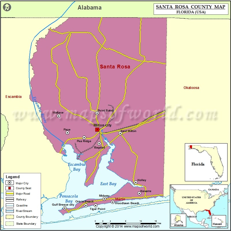
Check this Florida County Map to locate all the state’s counties in Florida Map.
Mountain Peaks in Santa rosa County
| Mountain Peak/Hill | Elevation [Meter] |
|---|---|
| The Mound | 5 |
Airports in Santa rosa County
| Airport Name |
|---|
| Blackwater Airfield |
| Buchanan Airport |
| Choctaw Nolf Airport |
| Chumuckla 20-20 Airport |
| Fort Walton Beach Airport |
| Garcon Field |
| George T Mc Cutchan Airport |
| Golden Harvest Flying Svc Inc Airport |
| Gulf Breeze Hospital Heliport |
| Harold Nolf Heliport |
| Holley Nolf Airport |
| J-22 Ranch Airport |
| Jay Airport |
| Jay Hospital Heliport |
| Odom’s Flying Service Airport |
| Pace Nolf Heliport |
| Peter Prince Field |
| Porter STOLport |
| Pullum Pad Heliport |
| Santa Rosa Medical Center Heliport |
| Santa Rosa Nolf Airport |
| Spencer Nolf Airport |
| Thomas Farms Airport |
| Wells Flying Service Airport |
| Whiting Field Naval Air Station North Airport |
| Whiting Field Naval Air Station South Airport |
Cities in Santa Rosa County
| City | Population | Latitude | Longitude |
|---|---|---|---|
| Allentown | 894 | 30.77367 | -87.08078 |
| Avalon | 679 | 30.536573 | -87.100834 |
| Bagdad | 3761 | 30.582394 | -87.044661 |
| Berrydale | 441 | 30.898163 | -87.035045 |
| Brownsdale | 471 | 30.885943 | -87.22176 |
| Chumuckla | 850 | 30.782606 | -87.230967 |
| Cobbtown | 67 | 30.882309 | -87.121156 |
| Dickerson City | 146 | 30.48262 | -87.065034 |
| Dixonville | 181 | 30.986789 | -87.041753 |
| East Milton | 11074 | 30.617536 | -86.963864 |
| Fidelis | 156 | 30.934319 | -87.024533 |
| Floridatown | 244 | 30.582788 | -87.161334 |
| Garcon Point | 347 | 30.475819 | -87.089983 |
| Gulf Breeze city | 5763 | 30.368476 | -87.176884 |
| Harold | 823 | 30.677198 | -86.830923 |
| Holley | 1630 | 30.454073 | -86.903645 |
| Jay town | 533 | 30.950306 | -87.152207 |
| Midway | 16115 | 30.413825 | -87.026014 |
| Milton city | 8826 | 30.628545 | -87.052652 |
| Mount Carmel | 227 | 30.986766 | -87.121022 |
| Mulat | 259 | 30.559502 | -87.129755 |
| Munson | 372 | 30.841831 | -86.887135 |
| Navarre | 31378 | 30.417364 | -86.890844 |
| Oriole Beach | 1420 | 30.368726 | -87.096236 |
| Pace | 20039 | 30.618756 | -87.166716 |
| Pea Ridge | 3587 | 30.602914 | -87.102198 |
| Pine Level | 227 | 30.8887 | -87.168681 |
| Point Baker | 2991 | 30.684672 | -87.05241 |
| Roeville | 608 | 30.683773 | -86.993943 |
| Springhill | 160 | 30.756596 | -86.932932 |
| Tiger Point | 3090 | 30.377544 | -87.057862 |
| Wallace | 1785 | 30.674686 | -87.199567 |
| Whitfield | 295 | 30.878717 | -87.061332 |
| Woodlawn Beach | 1785 | 30.386089 | -86.993169 |
Golf Courses in Santa Rosa County
| Name of Golf Course | Latitude | Longitude |
|---|---|---|
| Stonebrook Golf Club-Pace | 30.640852 | -87.190484 |
| Tanglewood Golf & Country Club-Milton | 30.651319 | -87.080161 |
| The Club At Hidden Creek-Navarre | 30.438002 | -86.924117 |
| The Moors Golf & Lodging-Milton | 30.554329 | -87.087027 |
| Tiger Point Golf and Country Club-Gulf Breeze | 30.384119 | -87.079515 |
| Whiting Field Navy Golf Course-Milton | 30.633602 | -87.038158 |
National Parks in Santa Rosa County
| Name of Park | Latitude | Longitude |
|---|---|---|
| Gulf Islands NS | 30.367803 | -86.962915 |
 Wall Maps