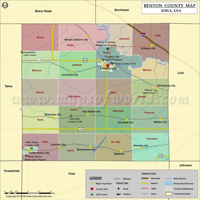
Airports in Benton County Airport Name Belle Plaine Municipal Airport Vinton Veterans Memorial Airpark Virginia Gay Hospital Heliport More Maps of Benton County Benton County Map, Tennessee Benton County Map,…
Airports in Benton County
Airport Name
Belle Plaine Municipal Airport
Vinton Veterans Memorial Airpark
Virginia Gay Hospital Heliport
More Maps of Benton County
Cities in Benton County
City
Population
Latitude
Longitude
Atkins city
1670
41.994246
-91.85856
Belle Plaine city
2534
41.895252
-92.2753
Blairstown city
692
41.90621
-92.082329
Garrison city
371
42.144013
-92.14316
Keystone city
622
41.999718
-92.198287
Luzerne city
96
41.905702
-92.180257
Mount Auburn city
150
42.257434
-92.094317
Newhall city
875
41.993329
-91.967341
Norway city
545
41.902221
-91.922667
Shellsburg city
983
42.092941
-91.870984
Urbana city
1458
42.228386
-91.887266
Van Horne city
682
42.009687
-92.089568
Vinton city
5257
42.163895
-92.026081
Watkins
118
41.893102
-91.984993
Golf Courses in Benton County
Name of Golf Course
Latitude
Longitude
Belle Plaine Country Club-Belle Plaine
41.904173
-92.26858
Dysart Rec Golf Course-Dysart
42.208776
-92.298701
Tara Hills Country Club-Van Horne
42.00693
-92.143519
Vinton Country Club-Vinton
42.173035
-92.013208
Wildcat Golf Course-Shellsburg
42.087352
-91.875965

 Wall Maps