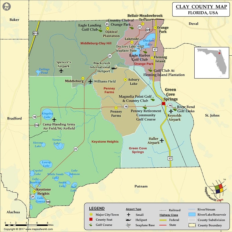
Check this Florida County Map to locate all the state’s counties in Florida Map.
Clay County is one of the counties in the state of Florida in the US. The total population of this county was 190,895, as per the 2010 census. Green Cove Springs, Florida is its county seat. The county was named in honor of Henry Clay, who was a United States Secretary of State in the 19th century and an American statesman, and a member of the United States Senate from Kentucky.
The total area covered by this county is 644 square miles (1,670 km2). Out of this, 604 square miles (1,560 km2) are land and 39 square miles (100 km2) (6.1%) are water.
Clay County is situated along some highways. Some of those are US 17, US 301, SR 16, SR 21, SR 23, and SR 100. the counties located adjacent to Clay County are Duval County, Florida – north, St. Johns County, Florida – east, Putnam County, Florida – south, Bradford County, Florida – west, and Baker County, Florida – northwest. The nearest airport is Keystone Heights Airport.
Doctors Lake, The Middleburg United Methodist Church, Gold Head Branch State Park, Wings of Dreams Aviation Museum, and Black Creek are some of the attractions in Clay County.
More Maps of Clay County
- Clay County Map, South Dakota
- Clay County Map, Nebraska
- Clay County Map, Alabama
- Clay County Map, North Carolina
- Clay County Map, Texas
- Clay County Map, Tennessee
- Clay County Map, Georgia
Airports in Clay County
| Airport Name |
|---|
| Blackcreek International Heliport |
| Camp Blanding Army Air Field/NG Airfield |
| Doctors Lake Seaplane Base |
| Haller Airpark |
| Reynolds Airpark |
| Spencer’s Airpark |
| Williams Field |
Cities in Clay County
| City | Population | Latitude | Longitude |
|---|---|---|---|
| Asbury Lake | 8700 | 30.047239 | -81.785521 |
| Bellair-Meadowbrook Terrace | 13343 | 30.179644 | -81.737771 |
| Fleming Island | 27126 | 30.098834 | -81.712434 |
| Green Cove Springs city | 6908 | 29.990294 | -81.680743 |
| Keystone Heights city | 1350 | 29.780962 | -82.033904 |
| Lakeside | 30943 | 30.13574 | -81.767411 |
| Middleburg | 13008 | 30.050363 | -81.901207 |
| Oakleaf Plantation | 20315 | 30.168917 | -81.833641 |
| Orange Park town | 8412 | 30.170628 | -81.70404 |
| Penney Farms town | 749 | 29.980277 | -81.810732 |
Golf Courses in Clay County
| Name of Golf Course | Latitude | Longitude |
|---|---|---|
| Country Club of Orange Park-Orange Park | 30.170098 | -81.766717 |
| Eagle Harbor Golf Club-Fleming Island | 30.112803 | -81.729926 |
| Eagle Landing Golf Club-Orange Park | 30.163713 | -81.852419 |
| Golf Club At Fleming Island Plantation-Fleming Island | 30.069357 | -81.716192 |
| Magnolia Point Golf & Country Club-Green Cove Springs | 29.999727 | -81.709334 |
| Penney Retirement Community-Penney Farms | 29.983656 | -81.730744 |
| River Bend Golf Links-Green Cove Springs | 29.979562 | -81.650541 |

 Wall Maps