- Neighboring Countries - Haiti, Cuba, Dominican Republic
- Continent And Regions - North America Map, Americas Map
- Other Jamaica Maps - Jamaica Map, Where is Jamaica, Jamaica Blank Map, Jamaica Road Map, Jamaica Rail Map, Jamaica River Map, Jamaica Cities Map, Jamaica Physical Map, Jamaica Flag
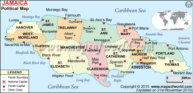
Jamaica is an excellent country in terms of its exotic destinations and the modern cities in Jamaica are another important factor. Jamaica’s political map denotes the parishes, capital of parishes, and important cities of Jamaica.
There are a large number of cities in Jamaica. Some of them are Lucea, Montpelier, Portmore, Mandeville, and Duncans.
Jamaica covers an area of about 10,991 sq km. Kingston is the national capital of Jamaica.
The geographical position of Jamaica
Jamaica is located on the geographical coordinates of 18° 15′ North and 77° 30′ West latitude and longitude respectively. It is situated in the south of Cuba in the Caribbean Sea. The coastline measures about 1,022 km. It covers an area of 10,991 sq km. Jamaica’s political map shows the parishes, capital of parishes, and important cities along with the national and international boundaries of Jamaica.
The parishes of Jamaica along with their capital and major cities are as follows:
- Hanover: Capital- Lucea
- Saint James: Capital- Montego Bay, Major City- Montpelier
- Trelawny: Capital- Falmouth, Major City- Duncans and Albert Town
- Saint Ann: Capital- Saint Ann’s Bay, Major City- Brown’s Town and Moneague
- Saint Mary: Capital- Port Maria, Major City- Annotto Bay, Oracabessa
- Portland: Capital- Port Antonio, Major City- Bluff Bay
- Saint Thomas: Capital- Morant Bay
- Kingston
- Saint Catherine: Capital- Spanish Town, Major City- Portmore
- Clarendon: Capital- May Pen, Major City- the Alley
- Manchester: Capital- Mandeville
- Saint Elizabeth: Capital- Black River
- Westmoreland: Capital- Savanna-la-Mar, Major City- Bluefields and Negril
The parishes are marked with jet black on the Jamaica political map. The capital cities of the parishes are shown by a green square box on Jamaica Map. Besides these, the cities of Jamaica are symbolized with black dots.
Bays surrounding Jamaica
The bays surrounding Jamaica are:
- Montego Bay.
- Annotto Bay.
- Long Bay.
- Black River Bay.
- Bluefields Bay.
The Jamaica channel is located on the eastern side and the Portland Bight is located on the southern side of Jamaica. The national boundary is shown on the map by red uneven lines and the international boundary is shown by black uneven lines.
Kingston, the Jamaican Capital
Kingston, the national capital of Jamaica, is located at 18° North latitude and 76° 48′ West longitude. A red star denotes the capital city of Jamaica on the printable map of Jamaica. Kingston is situated at an elevation of 53 meters. This place can be accessed from the airports of Ken Jones, Tinson Pen, Boscobel, and Norman Manley International.
Some of the towns and cities located near Kingston are New Kingston, Kencot, Cassia Park, Jones Town, Delacree Pen, Cockburn Gardens, Admiral Town, Whitfield Town, Camperdown, and Eastwood Park.
| Parish | Population | Area(km.²) | Area(mi.²) | Capital |
|---|---|---|---|---|
| Clarendon | 237,024 | 1,196 | 462 | May Pen |
| Hanover | 67,037 | 450 | 174 | Lucea |
| Kingston | 96,052 | 22 | 8 | Kingston |
| Manchester | 185,801 | 830 | 320 | Mandeville |
| Portland | 80,205 | 814 | 314 | Port Antonio |
| Saint Andrew | 555,828 | 431 | 166 | Half Way Tree |
| Saint Ann | 166,762 | 1,213 | 468 | Saint Anns Bay |
| Saint Catherine | 482,308 | 1,192 | 460 | Spanish Town |
| Saint Elizabeth | 146,404 | 1,212 | 468 | Black River |
| Saint James | 175,127 | 595 | 230 | Montego Bay |
| Saint Mary | 111,466 | 611 | 236 | Port Maria |
| Saint Thomas | 91,604 | 743 | 287 | Morant Bay |
| Trelawny | 73,066 | 875 | 338 | Falmouth |
| Westmoreland | 138,947 | 807 | 312 | Savanna-la-Mar |
| 14 parishes | 2,607,632 | 10,991 | 4,243 |
Political Maps of the bordering countries:
 Wall Maps