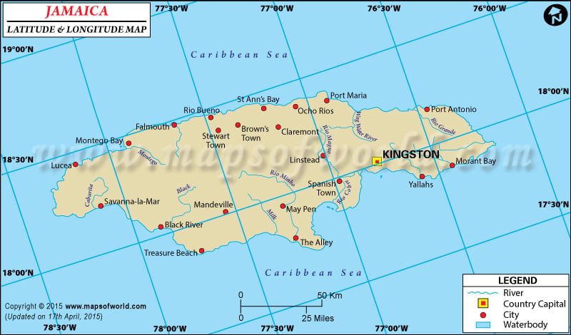
The geographical alignment of Jamaica includes latitude of 18° 15' N and longitude of 77° 30' W. The particular latitude of Jamaica shows its position in Northern Hemisphere and its moderate proximity to the equator.
Jamaica is a island located in the Caribbean Sea towards the south of Cuba.
The country of Jamaica has an area of 10,991 square kilometers. The terrain of Jamaica is pervaded by crags and cliffs, while the shore line is broken and irregular.
The climate of Jamaica is tropical and the conditions are warm and humid.
The central part is dominated by moderate weather. The latitude and the longitude of Kingston, the capital of Jamaica, are 18° 00' N and 76° 48' W respectively. The time followed in Jamaica is UTC-5 which signifies that the standard time of Jamaica is similar as Washington.
Latitude and Longitude of Jamaica |
|---|
| Location | Latitude | Longitude |
|---|
| Annotto Bay | 18°17'N | 76°45'W |
| Black River | 18°00'N | 77°50'W |
| Cambridge | 18°18'N | 77°54'W |
| Falmouth | 18°30'N | 77°40'W |
| Kingston | 18°00'N | 76°50'W |
| Lucea | 18°25'N | 78°10'W |
| May Pen | 17°58'N | 77°15'W |
| Montego Bay | 18°30'N | 78°0'W |
| Morant Cays | 17°22'N | 76°0'W |
| Morant Pt. | 17°55'N | 76°12'W |
| Negril | 18°22'N | 78°20'W |
| Pedro Cays | 17°05'N | 77°48'W |
| Port Antonio | 18°10'N | 76°30'W |
| Port Maria | 18°25'N | 76°55'W |
| Port Morant | 17°54'N | 76°19'W |
| St. Ann's Bay | 18°26'N | 77°15'W |
| Savanna-la-Mar | 8°10'N | 78°10'W |
| South Negril Pt. | 18°14'N | 78°30'W |
Last Updated on: November 17th, 2017


