- Neighboring Countries - Dominican Republic, Jamaica, Cuba
- Continent And Regions - North America Map, Americas Map
- Other Haiti Maps - Haiti Map, Where is Haiti, Haiti Blank Map, Haiti Road Map, Haiti Rail Map, Haiti River Map, Haiti Cities Map, Haiti Physical Map, Haiti Flag
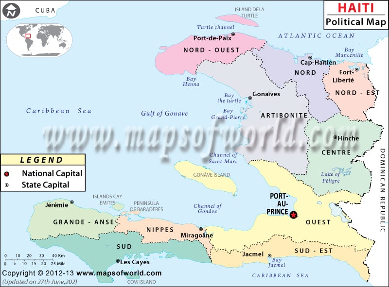
The political map of Haiti gives detailed information about the country’s capital, administrative divisions, and also neighboring country. The total area of the country is 27,750 square kilometers. However, the latitudinal and longitudinal extent of the country is 19° North and 72°25′ West respectively. Situated at an altitude of 98 meters above sea level is the country’s capital Port-au-Prince.
The colored map of Haiti features the administrative divisions of the country along with showcasing the important cities and the national capital. The black dots on the printable map of Haiti represent important cities of the country. Haiti shares its borders with the Dominion Republic as shown in the online political map of Haiti. The broken line demarcates the administrative borders while a dotted broken line demarcates the international border. The coastline of the country is outlined by a blue line.
Location and Geography of Haiti
The latitudinal and longitudinal extent of the country is 19° North and 72° 25′ West respectively. The country is situated in the western part of the Dominion Republic. The country’s total land area measures 27, 560 square kilometers, and the area covered by water bodies is 190 square kilometers. The total area on the map of Haiti sums up to 27, 750 square kilometers. The coastline of the country is spread over an area of 1,771 kilometers. Chaine de la Selle is the highest point of Haiti, situated at a height of 2,680 meters while the lowest point is the Caribbean Sea.
Country Capital of Haiti
Port-au-Prince is the capital of Haiti, which is pointed with a red dot within a square on the map of Haiti. The geographical coordinates of the city are 18°32’21”North latitude and 72°20’6”West longitude. It is the largest city in the country situated at an altitude of 98 meters above sea level. The nearby cities are:
- Bolasse
- Cite Numero Un
- Bourdon
- Canape Vert
- Deprez
- Cite Numero Deux
- Turgeau
- Fort Mercredi.
The city can be accessed by the three airports, Port Au Prince International, Cabo Rojo, and Jacmel.
Administrative Divisions and Important Cities of Haiti
The map of Haiti clearly demarcates the administrative divisions of the country. They are:
- Artibonite
- Grand’ Anse
- Nord
- Centre
- Nippes
- Nord-Est
- Sud
- Sud-Est
- Quest
- Nord-Quest
Some of the important cities of Haiti as shown in the map are Port-de-Paix, Le Borgne, Limbe, Ennery, Hinche, Saint- Marc, Lafond, Jeremie, Dame-Marie, Bainet, Belle-Anse, Les Cayes, Port Salut, Petite Goave, Pestel and Manneville.
| Department | Pop-2003 | Area(km.²) | Area(mi.²) | Capital | Formerly |
|---|---|---|---|---|---|
| L’Artibonite | 1,070,397 | 4,887 | 1,887 | Gonaives | L’Artibonite |
| Centre | 565,043 | 3,487 | 1,346 | Hinche | L’Artibonite, Ouest, Nord |
| Grand’ Anse | 337,516 | 1,912 | 738 | Jeremie | Sud |
| Nippes | 266,379 | 1,267 | 489 | Miragoane | Sud |
| Nord | 773,546 | 2,115 | 817 | Cap-Haitien | Nord |
| Nord-Est | 300,493 | 1,623 | 627 | Fort-Liberte | Nord |
| Nord-Ouest | 445,080 | 2,103 | 812 | Port-de-Paix | Nord-Ouest |
| Ouest | 3,093,698 | 4,983 | 1,924 | Port-au-Prince | Ouest |
| Sud | 627,311 | 2,653 | 1,024 | Les Cayes | Sud |
| Sud-Est | 449,585 | 2,034 | 785 | Jacmel | Ouest |
| 10 departments | 7,929,048 | 27,075 | 10,454 |
 Wall Maps
 Facts about Haiti