- South Dakota Counties - South Dakota County Map, Map of South Dakota Counties
- Major Cities of South Dakota - Pierre
- Neighbouring States - North Dakota, Iowa, Minnesota, Nebraska, Wyoming , Montana
- Regional Maps - Map of USA
- Other South Dakota Maps - South Dakota Map, Where is South Dakota, South Dakota Physical Map, South Dakota Lati Long Map, South Dakota Zip Code Map, South Dakota Area Code Map, South Dakota National Parks Map
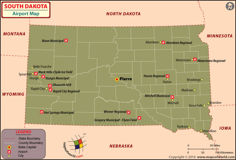
There are 75 airports in South Dakota for the public to use. There are also many private airports in South Dakota as there are avid fliers in the state. The South Dakota airports are well maintained and well connected to major cities in the USA.
Airports in South Dakota
There are no international airports in South Dakota. The important regional Airports in South Dakota are the Aberdeen Regional Airport at Aberdeen, the Pierre Regional Airport at Pierre, the Rapid City Regional Airport at Rapid City, the Sioux Falls Regional Airport at Sioux Falls and the Watertown Regional Airport at Watertown. Apart from these there are also general aviation airports in South Dakota to manage the growing number of passengers each year. Specifically, the Aberdeen Regional Airport is the one which hosted the first fly-in event in South Dakota in the year 1923. Also, during the World War II, the airfield was utilized by the United States Army Air Forces as the contract glider training airfield that was owned by Anderson & Brennan Flying Service.
The Watertown Regional Airport has many amenities and services to offer. The terminal is well equipped to meet the needs of the passengers despite the airport not being a very large one. The terminal of the Watertown Regional Airport has a vending machine that is not as expensive as the ones at other airports. There is an excellent flight information system. The airport has a large conference room for the busy travelers who like to be in touch with their business even while on the move. To that end the airport also provides free wireless Internet connection and the passengers need to find out the details of the same from the airport. The airport also tries to maintain a warm atmosphere by allowing the family and friends of the traveler to stay in the terminal till the flight has arrived. The airport is also one of its kinds in its policy regarding parking. It does not charge for parking and one can park his/her car for free as long as he/she is on the trip. The airline that serves at this airport is the Mesaba Airlines.
One can book the tickets to the above-mentioned airline(s) online. Some of the airlines offer special fares and discounts for the online booking of their tickets. The other important airports in South Dakota are at Lemmon, Spearfish, Pine Ridge, Huron, Brookings, Madison, Mitchell, Sioux Falls, Carton, and Yankton The Sioux Falls Regional Airport.
The airlines that serve this airport are Northwest Airlines, Northwest Airlink, United Express, Allegiant Air, Delta Airlines, Mesaba Airlines and Pinnacle Airlines.
Maps of Major Airports in South Dakota
- Aberdeen Regional Airport Map
- Rapid City Regional Airport Map
- Sioux Falls Regional Airport Map
- Watertown Regional Airport Map
List of Airports in South Dakota |
|---|
| Airport Name | Airport Code | City | Country | Type | Coordinates |
|---|---|---|---|---|---|
| Aberdeen Regional Airport | ABR | Aberdeen | South Dakota | Domestic | 45°26′53.8″N 098°25′21.9″W |
| Pierre Regional Airport | PIR | Pierre | South Dakota | Domestic | 44°22′58″N 100°17′10″W |
| Rapid City Regional Airport | RAP | Rapid City | South Dakota | Domestic | 44°02′43″N 103°03′26″W |
| Sioux Falls Regional Airport | FSD | Sioux Falls | South Dakota | Domestic | 43°34′55″N 096°44′31″W |
| Watertown Regional Airport | ATY | Watertown | South Dakota | Domestic | 44°54′50″N 097°09′17″W |
| Huron Regional Airport | HON | Huron | South Dakota | Domestic | 44°23′07″N 098°13′43″W |
| Arlington Municipal Airport | — | Arlington | South Dakota | Municipal | 44°23′40″N 097°07′23″W |
| Graham Field | — | North Sioux City | South Dakota | — | 42°32′25″N 096°29′06″W |
| Rosebud Sioux Tribal Airport | — | Rosebud | South Dakota | — | 43°15′30″N 100°51′34″W |
 Wall Maps