- South Dakota Counties - South Dakota County Map, Map of South Dakota Counties
- Major Cities of South Dakota - Pierre
- Neighbouring States - North Dakota, Iowa, Minnesota, Nebraska, Wyoming , Montana
- Regional Maps - Map of USA
- Other South Dakota Maps - South Dakota Map, Where is South Dakota, South Dakota Airports Map, South Dakota Lati Long Map, South Dakota Zip Code Map, South Dakota Area Code Map, South Dakota National Parks Map
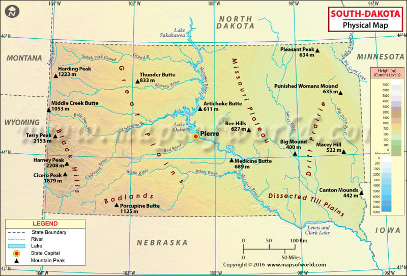
The state of South Dakota in the Midwestern United States is divided into three geographic regions. Eastern South Dakota is relatively lower in elevation than the western portion of the state. Geography of Western South Dakota has more similarity to the West than the Midwest.
The Missouri River – the longest river in South Dakota and the US – serves as geographic, social, and political border between eastern and western region. The Black Hills are an isolated mountain group in the southwestern corner of the state.
Like most of land in the Great Plains, mean elevation in South Dakota also rises from east towards west. The Missouri Plateau covers the central region of the state. Sub-regions in Eastern South Dakota include the Coteau des Prairies, the Dissected Till Plains, and the James River Valley. The Coteau des Prairies is located between the Minnesota River Valley and the James River Basin. The Dissected Till Plains comprises an area of rolling hills and fertile soil in southeastern corner of South Dakota.
The fertile expanse of the Great Plains of North America cover most of the western two-thirds of the state. The landscape west of the Missouri River becomes more rugged and consists of rolling hills, ravines, and flat-topped hills called buttes, which rise up to 600 feet above the plains. In the south and directly east of the Black Hills lie the South Dakota Badlands. This series of odd-shaped and brightly-colored buttes and domes cover the badlands. The highest point in South Dakota, Black Elk Peak has an elevation of 7,242 feet or 2,207 meters above sea level.
In the far northeast, the terrain along the Red River is flat that gives way for rolling hills as the primary landforms in the south. Other major rivers in South Dakota include the Cheyenne, the James, the Big Sioux, and the White. Lake Thompson, Lake Poinsett, and Lake Kampeska are major natural lakes; while Lake Oahe, Lake Sharpe, Lake Francis Case, and Lewis, and Clark Lake are large reservoirs.
 Wall Maps