- Iowa Counties - Iowa County Map, Map of Iowa Counties
- Major Cities of Iowa - Des Moines, Waterloo
- Neighbouring States - Minnesota, Wisconsin, Illinois, Missouri, Nebraska, South Dakota
- Regional Maps - Map of USA
- Other Iowa Maps - Iowa Map, Where is Iowa, Iowa Physical Map, Iowa Lat Long Map, Iowa Zip Code Map, Iowa Area Code Map
Airports in Iowa
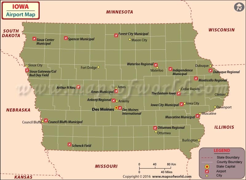
Iowa is a fairly large state with 122 airports. The Airports in Iowa are well connected to the other states in the US. The only international airport in Iowa is the Des Moines International Airport, which receives almost two million passengers annually. The airport is technologically up to date which makes flying as easy as is possible for the passengers regardless of the weather changes. The airport has deicing equipment to clear the runways and to keep it operational during the winter. It also offers hangar facilities for private airplanes. The airport is also conveniently located near the Flint Ridge Business Park.
Maps of Major Airports in Iowa
List of Airports in Iowa |
|---|
| Airport Name | Code | City | Hub | Enplanements (2015) |
|---|---|---|---|---|
| Des Moines International | DSM | Des Moines | S | 1,156,462 |
| The Eastern Iowa | CID | Cedar Rapids | S | 557,383 |
| Dubuque Regional | DBQ | Dubuque | N | 38,248 |
| Waterloo Regional | ALO | Waterloo | N | 26,950 |
| Sioux Gateway/Col Bud Day Field | SUX | Sioux City | N | 26,104 |
| Iowa City Municipal | IOW | Iowa City | None | 5,011 |
| Arthur N Neu | CIN | Carroll | None | 400 |
| Ames Municipal | AMW | Ames | None | 316 |
| Ankeny Regional | IKV | Ankeny | None | 177 |
| Clinton Municipal | CWI | Clinton | None | 20 |
| Forest City Municipal | FXY | Forest City | None | 19 |
| Spencer Municipal | SPW | Spencer | None | 7 |
| Ottumwa Regional | OTM | Ottumwa | None | 6 |
| Council Bluffs Municipal | CBF | Council Bluffs | None | 5 |
| Muscatine Municipal | MUT | Muscatine | None | 5 |
| Independence Municipal | IIB | Independence | None | 3 |
| Sioux Center Municipal | SOY | Sioux Center | None | 3 |
| Schenck Field | ICL | Clarinda | None | 1 |
| Monticello Regional | MXO | Monticello | None | 1 |
 Wall Maps