2.5K
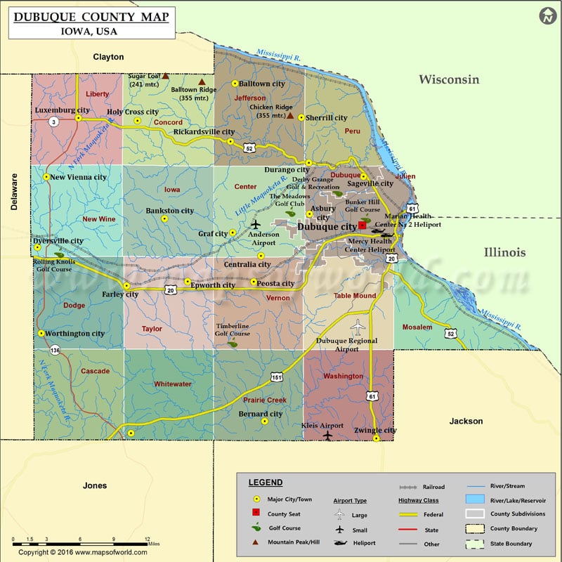
Mountain Peaks in Dubuque County
| Mountain Peak/Hill | Elevation [Meter] |
|---|---|
| Balltown Ridge | 355 |
| Sherrill Mound | 374 |
| Sugar Loaf | 241 |
Airports in Dubuque County
| Airport Name |
|---|
| Anderson Airport |
| Dubuque Regional Airport |
| Kleis Airport |
| Marian Health Center Nr 2 Heliport |
| Mercy Health Center Heliport |
Cities in Dubuque County
| City | Population | Latitude | Longitude |
|---|---|---|---|
| Asbury city | 4170 | 42.512118 | -90.773753 |
| Balltown city | 68 | 42.636884 | -90.869954 |
| Bankston city | 25 | 42.507663 | -90.96122 |
| Bernard city | 112 | 42.313581 | -90.83172 |
| Cascade city | 2159 | 42.302066 | -91.004592 |
| Centralia city | 134 | 42.472101 | -90.836521 |
| Dubuque city | 57637 | 42.501431 | -90.705546 |
| Durango city | 22 | 42.561072 | -90.774567 |
| Dyersville city | 4058 | 42.480298 | -91.125486 |
| Epworth city | 1860 | 42.447434 | -90.931255 |
| Farley city | 1537 | 42.443487 | -91.010234 |
| Graf city | 79 | 42.494303 | -90.872978 |
| Holy Cross city | 374 | 42.601222 | -90.996295 |
| Luxemburg city | 240 | 42.60385 | -91.072505 |
| New Vienna city | 407 | 42.547676 | -91.114009 |
| Peosta city | 1377 | 42.447393 | -90.845774 |
| Rickardsville city | 182 | 42.581439 | -90.875974 |
| Sageville city | 122 | 42.547908 | -90.703952 |
| Sherrill city | 177 | 42.604339 | -90.784259 |
| Worthington city | 401 | 42.397847 | -91.120562 |
| Zwingle city | 91 | 42.297076 | -90.687407 |
Golf Courses in Dubuque County
| Name of Golf Course | Latitude | Longitude |
|---|---|---|
| Bunker Hill Golf Course-Dubuque | 42.508068 | -90.700636 |
| Derby Grange Golf & Recreation-Dubuque | 42.533627 | -90.737255 |
| Dubuque Golf & Country Club-Dubuque | 42.485815 | -90.68093 |
| Dyersville Golf & Country Club-Dyersville | 42.486942 | -91.094411 |
| Rolling Knolls Golf Course-Dyersville | 42.474744 | -91.097451 |
| The Meadows Golf Club-Dubuque | 42.514284 | -90.798217 |
| Thunder Hills Country Club-Peosta | 42.451328 | -90.815451 |
| Timberline Golf Course-Peosta | 42.389243 | -90.873369 |
 Wall Maps