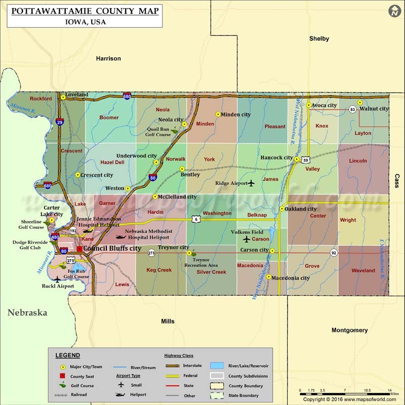
Pottawattamie County Map, Iowa
Airports in Pottawattamie County Airport Name Jennie Edmundson Hospital Heliport Nebraska Methodist Hospital Heliport Ridge Airport Ruckl Airport Volkens Field Cities in Pottawattamie County City Population Latitude Longitude Avoca city…
Airports in Pottawattamie County
Airport Name
Jennie Edmundson Hospital Heliport
Nebraska Methodist Hospital Heliport
Ridge Airport
Ruckl Airport
Volkens Field
Cities in Pottawattamie County
City
Population
Latitude
Longitude
Avoca city
1506
41.484076
-95.336325
Bentley
118
41.375546
-95.6225
Carson city
812
41.235923
-95.418543
Carter Lake city
3785
41.288461
-95.916933
Council Bluffs city
62230
41.239294
-95.854095
Crescent city
617
41.365489
-95.858159
Hancock city
196
41.392195
-95.363661
Loveland
35
41.497387
-95.891009
Macedonia city
246
41.191928
-95.426772
McClelland city
151
41.328473
-95.68343
Minden city
599
41.468376
-95.541177
Neola city
842
41.45167
-95.617212
Oakland city
1527
41.307773
-95.396725
Treynor city
919
41.232193
-95.606342
Underwood city
917
41.38695
-95.680855
Walnut city
785
41.488473
-95.220499
Weston
92
41.342098
-95.744928
Golf Courses in Pottawattamie County
Name of Golf Course
Latitude
Longitude
Avoca Golf Course-Avoca
41.491872
-95.333976
Bent Tree Golf Club-Council Bluffs
41.282391
-95.732541
Council Bluffs Country Club-Council Bluffs
41.215416
-95.851073
Dodge Riverside Golf Club-Council Bluffs
41.25226
-95.914368
Fox Run Golf Course-Council Bluffs
41.210991
-95.892439
Oakland Country Club-Oakland
41.316611
-95.389083
Quail Run Golf Course-Neola
41.441757
-95.64025
Shoreline Golf Course-Carter Lake
41.285174
-95.928094
Treynor Recreation Area-Treynor
41.23261
-95.598549
Westwood Park Golf Course-Council Bluffs
41.252283
-95.909059

 Wall Maps