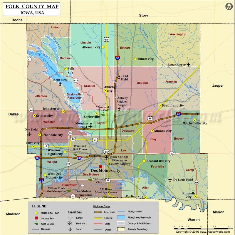
Airports in Polk County Airport Name Ankeny Regional Airport Day Field De Louis Field Des Moines International Airport Farrar Airport Iowa Lutheran Hospital Life Flight Heliport Iowa Methodist Medical Center…
Airports in Polk County
Airport Name
Ankeny Regional Airport
Day Field
De Louis Field
Des Moines International Airport
Farrar Airport
Iowa Lutheran Hospital Life Flight Heliport
Iowa Methodist Medical Center Heliport
Kern Field
Mercy Hospital Medical Center Private Heliport
Morningstar Field
Polk County Hospital Heliport
Rock Springs Sweetwater County Airport
Todd Field
Cities in Polk County
City
Population
Latitude
Longitude
Alleman city
432
41.815846
-93.60946
Altoona city
14541
41.646865
-93.476845
Ankeny city
45582
41.727898
-93.603202
Bondurant city
3860
41.6983
-93.455605
Carlisle city
3876
41.511629
-93.494868
Clive city
15447
41.614626
-93.797532
Des Moines city
203433
41.574135
-93.616507
Elkhart city
683
41.792288
-93.524248
Grimes city
8246
41.677644
-93.794966
Johnston city
17278
41.685586
-93.717252
Mitchellville city
2254
41.667877
-93.362909
Pleasant Hill city
8785
41.585737
-93.499699
Polk City city
3418
41.772236
-93.710033
Runnells city
507
41.514055
-93.360397
Saylorville
3301
41.681038
-93.627771
Urbandale city
39463
41.638569
-93.7807
West Des Moines city
56609
41.55738
-93.766722
Windsor Heights city
4860
41.604196
-93.712793
Golf Courses in Polk County
Name of Golf Course
Latitude
Longitude
A H Blank Municipal Course-Des Moines
41.512022
-93.604151
Ankeny Golf & Country Club-Ankeny
41.72774
-93.6395
Beaver Creek Golf Course-Grimes
41.724658
-93.772033
Briarwood Golf Course-Ankeny
41.760162
-93.59364
Copper Creek Golf Course-Pleasant Hill
41.604304
-93.522528
Echo Valley Country Club-Norwalk
41.511682
-93.660484
Glen Oaks Country Club-West Des Moines
41.549938
-93.778309
Grandview Golf Course-Des Moines
41.616863
-93.561016
Hyperion Field Club-Johnston
41.69542
-93.706082
Jester Park Golf Course-Granger
41.777079
-93.78323
Otter Creek Golf Course-Ankeny
41.760991
-93.579853
Sleepy Hollow Sports Park-Des Moines
41.589964
-93.535214
Terrace Hills Golf Course-Altoona
41.644165
-93.426816
Toad Valley Public Golf Course-Des Moines
41.5327
-93.386634
Tournament Club of Iowa-Polk City
41.778558
-93.718821
Urbandale Golf & Country Club-Urbandale
41.633254
-93.736616
Wakonda Club-Des Moines
41.548944
-93.644732
Waveland Golf Course-Des Moines
41.600329
-93.68478
Willow Creek Golf Course Inc-West Des Moines
41.52658
-93.703179
Woodland Hills Golf-Des Moines
41.680347
-93.609914

 Wall Maps