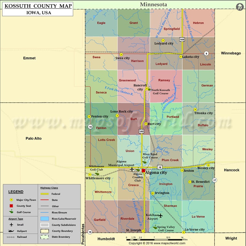
Airports in Kossuth County Airport Name Algona Municipal Airport Kohlhaas Airport Cities in Kossuth County City Population Latitude Longitude Algona city 5560 43.074317 -94.23012 Bancroft city 732 43.29262 -94.217367 Burt…
Airports in Kossuth County
Airport Name
Algona Municipal Airport
Kohlhaas Airport
Cities in Kossuth County
City
Population
Latitude
Longitude
Algona city
5560
43.074317
-94.23012
Bancroft city
732
43.29262
-94.217367
Burt city
533
43.198909
-94.221054
Fenton city
279
43.218157
-94.427967
Irvington
38
43.013546
-94.196051
Lakota city
255
43.377543
-94.093737
Ledyard city
130
43.420597
-94.158589
Lone Rock city
146
43.220807
-94.3255
Lu Verne city
261
42.909228
-94.083626
Sexton
37
43.074905
-94.089152
St. Benedict
39
43.044008
-94.06095
St. Joseph
61
42.91229
-94.230914
Swea City city
536
43.3833
-94.31092
Titonka city
476
43.236817
-94.041377
Wesley city
390
43.088672
-93.993686
Whittemore city
504
43.063391
-94.425054
Golf Courses in Kossuth County
Name of Golf Course
Latitude
Longitude
Algona Country Club-Algona
43.078095
-94.251079
North Kossuth Golf Course-Bancroft
43.293079
-94.211453
River Road Golf Course-Algona
43.098461
-94.226848
Spring Valley Golf Course-Livermore
42.923645
-94.188108
Whittemore Golf Club-Whittemore
43.067447
-94.399162

 Wall Maps