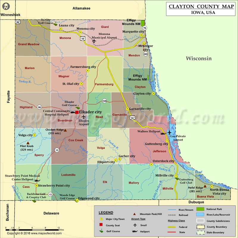
Mountain Peaks in Clayton County Mountain Peak/Hill Elevation [Meter] Chicken Ridge 355 Hefel Ridge 281 Pilot Knob 329 More Maps of Clayton County Clayton County Map, Georgia Airports in Clayton…
Mountain Peaks in Clayton County
Mountain Peak/Hill
Elevation [Meter]
Chicken Ridge
355
Hefel Ridge
281
Pilot Knob
329
More Maps of Clayton County
Airports in Clayton County
Airport Name
Central Community Hospital Heliport
Elkader Airport
Gaa Private Airport
Monona Municipal Airport
Strawberry Point Medical Center Heliport
Walters Heliport
Cities in Clayton County
City
Population
Latitude
Longitude
Clayton city
43
42.903315
-91.150574
Edgewood city
864
42.644235
-91.401734
Elkader city
1273
42.857579
-91.402359
Elkport city
37
42.741574
-91.27494
Farmersburg city
302
42.958867
-91.367069
Garber city
88
42.744429
-91.261817
Garnavillo city
745
42.866131
-91.23641
Guttenberg city
1919
42.788713
-91.105905
Luana city
269
43.059452
-91.455718
Marquette city
375
43.044601
-91.190565
McGregor city
871
43.024413
-91.182094
Millville city
30
42.70364
-91.076388
Monona city
1549
43.051273
-91.391204
North Buena Vista city
121
42.677621
-90.958506
Osterdock city
59
42.731386
-91.157834
St. Olaf city
108
42.926902
-91.38789
Strawberry Point city
1279
42.680339
-91.534957
Volga city
208
42.802667
-91.542274
Golf Courses in Clayton County
Name of Golf Course
Latitude
Longitude
Backbone Golf & Country Club-Strawberry Point
42.644082
-91.54372
Elkader Golf Course-Elkader
42.870054
-91.399987
Guttenberg Golf Club-Guttenburg
42.698615
-91.073628
Tri City Golf Course-Luana
43.071742
-91.473985
Woods Edge Golf Course-Edgewood
42.644528
-91.404879
National Parks in Clayton County
Name of Park
Latitude
Longitude
Effigy Mounds NM
43.086407
-91.187252
Effigy Mounds NM
42.940467
-91.167964

 Wall Maps