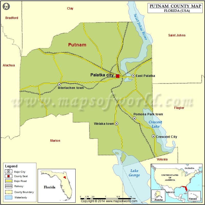
Check this Florida County Map to locate all the state’s counties in Florida Map.
Putnam County is situated in the state of Florida, the United States. As per the 2010 census, the total population of this county was 74,364. The county seat of Putnam County is Palatka, which is also the largest city in the county. The county got its name after Benjamin A. Putnam, a soldier in the First Seminole War, a lawyer, Florida legislator, and Florida Historical Society’s first president.
The total area of this county is 827 square miles (2,140 km2), out of which 728 square miles (1,890 km2) are covered by and 99 square miles (260 km2) (12.0%) are water.
The airport nearest to this county is Palatka Municipal Airport. The counties that are located adjacent to Putnam County include Clay County, Florida – north, St. Johns County, Florida – northeast, Flagler County, Florida – east, Volusia County, Florida – southeast, Marion County, Florida – southwest, Alachua County, Florida – west and Bradford County, Florida – northwest.
Some of the major attractions in this county are the Ocklawaha River, The Hawthorne Historical Museum & Cultural Center, The Bronson-Mulholland House, and Ravine Gardens State Park.
More Maps of Putnam County
Airports in Putnam County
| Airport Name |
|---|
| Columbia Putnam Community Hospital Heliport |
| Eagles Nest Aerodrome |
| Gottwald Field |
| Hilltop Ranch Airport |
| Inhome Medical Landing Heliport |
| Jim Finlay Farm Airport |
| Lib Field |
| Marjorie Kennan Rawlings Airport |
| Mount Royal Airport |
| Oak Ridge Airport |
| Pomona Landing Airport |
| Sanders Ranch Airport |
| Skinners Wholesale Nursery Airport |
| Thunderbird Air Park |
Cities in Putnam County
| City | Population | Latitude | Longitude |
|---|---|---|---|
| Crescent City city | 1577 | 29.437534 | -81.517482 |
| East Palatka | 1654 | 29.6506 | -81.598196 |
| Interlachen town | 1403 | 29.620287 | -81.89633 |
| Palatka city | 10558 | 29.648816 | -81.661805 |
| Pomona Park town | 912 | 29.501461 | -81.593766 |
| Welaka town | 701 | 29.482041 | -81.66581 |
Golf Courses in Putnam County
| Name of Golf Course | Latitude | Longitude |
|---|---|---|
| Live Oak Golf & Country Club-Crescent City | 29.410396 | -81.643151 |
| Palatka Golf Club-Palatka | 29.630233 | -81.649351 |

 Wall Maps