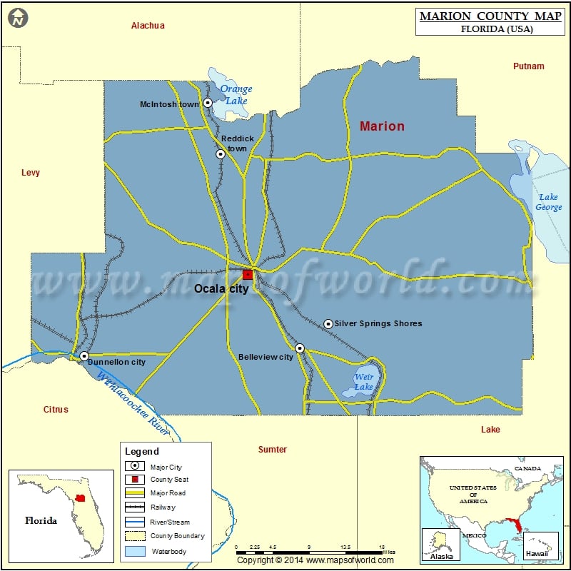
Check this Florida County Map to locate all the state’s counties in Florida Map.
Founded in 1844, Marion County is located between the Atlantic and the Gulf in north-central Florida. The county is named after General Francis Marion, who served in the American Revolutionary War. Its county seat and the largest city is Ocala. Covering a total area of 1,663 square miles, Marion County features rolling hills and live oaks and pines. The county lies within a two-hour drive from major cities in Florida. Putnam, Volusia, Sumter, Lake, Citrus, Levy, and Alachua are adjacent counties.
The Ocala National Forest covers most of the eastern portion of the county. Popular among nature lovers, the scenic Florida Trail passes through this forest. Silver Springs, the state’s first tourist attraction, is famous for glass-bottom boat tours that allow views of underwater flora and fauna. Recreational activities here include bicycling, canoeing, and camping.
The Appleton Museum of Art showcases permanent collections of European, American, and Contemporary artworks. The Don Garlits Museum of Drag Racing houses vintage hot rods and is popular among sports lovers. Fort King National Historic Landmark, Lake Weir, and Silver Springs Nature Park are other local attractions.
More Maps of Marion County
- Marion County Map, South Carolina
- Marion County Map, Alabama
- Marion County Map, Texas
- Marion County Map, Tennessee
- Marion County Map, Georgia
How to Reach
- Ocala International Airport (OCF) is the primary airport for general aviation.
- Interstate 75 and US 441 run north-south through the central part of the county.
Airports in Marion County
| Airport Name |
|---|
| 85th Avenue Airstrip |
| Arliss M Airport |
| Back Achers Airport |
| Bayou Fourchon Seaplane Base |
| Bernie Little Heliport |
| Cloverleaf Farms Ii Inc. Heliport |
| Cloverleaf Farms Ii Inc. Heliport |
| Crosswind Farm Airport |
| Drake Ranch Airport |
| Dunnellon Marion Co & Park of Commerce Airport |
| Fenner Ranch Airport |
| Fly’n R Ranch Airport |
| Flying Dutchman Ranch Airport |
| Flying Exotics Airport |
| Hobby Hill STOLport |
| Idle Wild Airport |
| Johary Airport |
| Jordan Heliport |
| Jordan Heliport |
| Jumbolair-Greystone Airport |
| Lake Weir Seaplane Base |
| Lee Farms Airport |
| Leeward Air Ranch Airport |
| Lockheed Martin-Ocala Heliport |
| Love Field |
| Marion Correctional Institution Heliport |
| Mc Ginley Airport |
| Monroe Airpark |
| Norton Airport |
| Ocala International Jim Taylor Field |
| Paniola Air Ranch Airport |
| Seven Springs Ranch Airport |
| Shady International Airport |
| Sheriff’s North Multi District Office Heliport |
| The Villages Heliport |
| Thompson’s Goinbroke Aero Ranch Airport |
| Woods and Lakes Airpark |
Cities in Marion County
| City | Population | Latitude | Longitude |
|---|---|---|---|
| Belleview city | 4492 | 29.064885 | -82.05636 |
| Dunnellon city | 1733 | 29.052959 | -82.44141 |
| McIntosh town | 452 | 29.449329 | -82.220974 |
| Ocala city | 56315 | 29.180312 | -82.14878 |
| Reddick town | 506 | 29.368758 | -82.197408 |
| Silver Springs Shores | 6539 | 29.103074 | -82.004984 |
Golf Courses in Marion County
| Name of Golf Course | Latitude | Longitude |
|---|---|---|
| Baseline Golf Course-Ocala | 29.091359 | -82.053692 |
| Candler Hills Golf and Country Club-Ocala | 29.103447 | -82.260524 |
| Country Club At Silver Springs Shores-Ocala | 29.103767 | -82.000306 |
| Country Club of Ocala-Ocala | 29.110911 | -82.118919 |
| Eagle Ridge At Spruce Creek Country Club-Summerfield | 29.020943 | -81.998292 |
| Golden Hills Golf & Turf Club-Ocala | 29.236397 | -82.251293 |
| Golden Ocala Golf and Country Club-Ocala | 29.218811 | -82.257324 |
| Grand Lake RV and Golf Resort-Citra | 29.425686 | -82.205475 |
| Huntington Golf Club-Ocala | 29.011605 | -82.231606 |
| Juliette Falls Golf and Spa Club-Dunnellon | 29.117939 | -82.416673 |
| Lake Diamond Golf & Country Club-Ocala | 29.12754 | -82.015992 |
| Marion Oaks Country Club-Ocala | 28.985781 | -82.192446 |
| Nancy Lopez Legacy Golf & Country Club-The Villages | 28.971629 | -82.013052 |
| Oak Run Country Club-Ocala | 29.059132 | -82.268573 |
| Ocala Palms Golf & Country Club-Ocala | 29.212516 | -82.205552 |
| On Top of the World Golf Course-Ocala | 29.08182 | -82.271156 |
| Pine Oaks Golf Course-Ocala | 29.208207 | -82.161495 |
| Rainbow Springs Golf & Country Club-Dunnellon | 29.101614 | -82.441353 |
| Rainbow’s End Golf and Country Club-Dunnellon | 29.104341 | -82.463512 |
| Rolling Greens Executive Course-Ocala | 29.172989 | -82.036665 |
| Royal Oaks Golf Club-Ocala | 29.059624 | -82.233914 |
| Stone Creek Golf Club-Ocala | 29.123626 | -82.270665 |
| Stonecrest Golf Club-Summerfield | 28.966463 | -81.961633 |
| SummerGlen Country Club-Ocala | 28.990771 | -82.15102 |
| The Golf Club of Ocala-Ocala | 29.192678 | -82.093614 |
| The Links of Spruce Creek-Summerfield | 28.968953 | -81.974661 |
| The Spruce Creek Preserve Golf Club-Dunnellon | 29.024415 | -82.310147 |

 Wall Maps