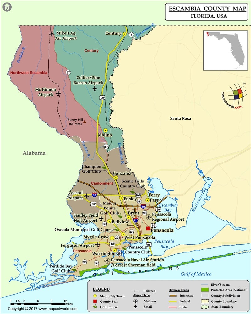
Escambia County Map, Florida
Check this Florida County Map to locate all the state’s counties in Florida Map. Mountain Peaks in Escambia County Mountain Peak/Hill Elevation [Meter] Rocky Mound 32 Sabine Sand Hills 3 Sand Mound 18…
Check this Florida County Map to locate all the state’s counties in Florida Map .
Mountain Peaks in Escambia County
Mountain Peak/Hill
Elevation [Meter]
Rocky Mound
32
Sabine Sand Hills
3
Sand Mound
18
Sunny Hill
61
More Maps of Escambia County
Airports in Escambia County
Airport Name
Baptist Hospital Heliport
Coastal Airport
Collier/Pine Barren Airpark
Ferguson Airport
Mc Kinnon Airpark
Mike’s Ag Air Airport
Pensacola Naval Air Station/Forrest Sherman field
Pensacola Regional Airport
Sacred Heart Hospital Heliport
Saufley Field Nolf Airport
West Florida Regional Medical Center Heliport
Cities in Escambia County
City
Population
Latitude
Longitude
Bellview
23355
30.462029
-87.312021
Brent
21804
30.47286
-87.249591
Century town
1698
30.976624
-87.262865
Ensley
20602
30.526071
-87.273497
Ferry Pass
28921
30.520141
-87.190374
Gonzalez
13273
30.582211
-87.290591
Goulding
4102
30.439627
-87.229916
Molino
1277
30.71228
-87.32398
Myrtle Grove
15870
30.415772
-87.302758
Navarre Beach
638
30.380986
-86.88726
Pensacola city
51923
30.442658
-87.188554
Warrington
14531
30.382106
-87.294423
West Pensacola
21339
30.426306
-87.267865
Golf Courses in Escambia County
Name of Golf Course
Latitude
Longitude
A. C. Read Golf Club-Pensacola
30.347967
-87.301821
Carriage Hills Golf Club-Pensacola
30.457458
-87.283016
Champion Golf Club-Cantonment
30.610119
-87.326153
Marcus Pointe Golf Club-Pensacola
30.475736
-87.275554
Osceola Municipal Golf Course-Pensacola
30.439024
-87.286611
Pensacola Country Club-Pensacola
30.387377
-87.262098
Perdido Bay Golf Club-Pensacola
30.328419
-87.421968
Saufley Golf Course Netpmsa-Pensacola
30.461889
-87.335014
Scenic Hills Country Club-Pensacola
30.542993
-87.236289
Solutia Golf Club-Cantonment
30.582892
-87.272609
National Parks in Escambia County
Name of Park
Latitude
Longitude
Gulf Islands NS
30.367803
-86.962915

 Wall Maps