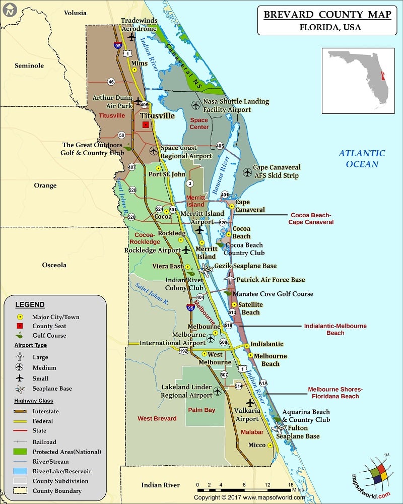
Check this Florida County Map to locate all the state’s counties in Florida Map.
Brevard County
Brevard County is located in Central Florida along the Atlantic Ocean. The county is also known as the Space Coast due to the location of the iconic John F. Kennedy Space Center. It covers an area of 1,557 square miles which is larger than the island nation of Samoa and one-third the size of Rhode Island state. As of the 2015 census, about 568,088 people live in the county.
Titusville is the county seat and Palm Bay is the largest city. Volusia, Indian River, Osceola, and Orange are the neighboring counties. Brevard County is known for a variety of flora and fauna thriving in wildlife refuges. The Brevard Zoo, Kennedy Space Center Visitor Complex, Brevard Museum of History, and Cocoa Beach are major tourist attractions.
Mountain Peaks in Brevard County
| Mountain Peak/Hill | Elevation [Meter] |
|---|---|
| Honeymoon Hill | 9 |
| Mulberry Mound | 6 |
Airports in Brevard County
| Airport Name |
|---|
| Arthur Dunn Air Park |
| Cape Canaveral AFS Skid Strip |
| Cape Canaveral Hospital Heliport |
| Fulton Seaplane Base |
| Gezik Seaplane Base |
| Holmes Regional Medical Center Heliport |
| Hospital Heliport |
| Knobel Heliport |
| Lakeland Linder Regional Airport |
| Melbourne International Airport |
| Merritt Island Airport |
| Nasa Shuttle Landing Facility Airport |
| Nierenberg Estate Heliport |
| Patrick Air Force Base |
| Porta Target Heliport |
| Rockledge Airport |
| Space Coast Regional Airport |
| Tradewinds Aerodrome |
| Va Outpatient Clinic Heliport |
| Valkaria Airport |
| Wuesthoff Hospital Emergency Heliport |
Cities in Brevard County
| City | Population | Latitude | Longitude |
|---|---|---|---|
| Cape Canaveral city | 9912 | 28.393778 | -80.605355 |
| Cocoa Beach city | 11231 | 28.332918 | -80.625328 |
| Cocoa city | 17140 | 28.382077 | -80.767441 |
| Cocoa West | 5925 | 28.359514 | -80.771157 |
| Grant-Valkaria town | 3850 | 27.932275 | -80.565438 |
| Indialantic town | 2720 | 28.086956 | -80.567745 |
| Indian Harbour Beach city | 8225 | 28.152504 | -80.595713 |
| June Park | 4094 | 28.070944 | -80.686259 |
| Malabar town | 2757 | 27.988528 | -80.578012 |
| Melbourne Beach town | 3101 | 28.066829 | -80.558851 |
| Melbourne city | 76068 | 28.115951 | -80.646001 |
| Melbourne Village town | 662 | 28.087916 | -80.665058 |
| Merritt Island | 34743 | 28.314643 | -80.671259 |
| Micco | 9052 | 27.868306 | -80.510007 |
| Mims | 7058 | 28.692867 | -80.846725 |
| Palm Bay city | 103190 | 27.986055 | -80.662783 |
| Palm Shores town | 900 | 28.19213 | -80.659604 |
| Patrick AFB | 1222 | 28.234186 | -80.607892 |
| Port St. John | 12267 | 28.47705 | -80.787457 |
| Rockledge city | 24926 | 28.319973 | -80.731479 |
| Satellite Beach city | 10109 | 28.178111 | -80.599418 |
| Sharpes | 3411 | 28.43686 | -80.755548 |
| South Patrick Shores | 5875 | 28.201922 | -80.61405 |
| Titusville city | 43761 | 28.572416 | -80.819285 |
| Viera East | 10757 | 28.260855 | -80.714936 |
| Viera West | 6641 | 28.243087 | -80.736818 |
| West Melbourne city | 18355 | 28.069928 | -80.673245 |
Golf Courses in Brevard County
| Name of Golf Course | Latitude | Longitude |
|---|---|---|
| Aquarina Beach & Country Club-Melbourne Beach | 27.922619 | -80.489927 |
| Barefoot Bay Golf Course-Barefoot Bay | 27.889354 | -80.527324 |
| Baytree National Golf Links-Melbourne | 28.217063 | -80.709266 |
| Cocoa Beach Country Club-Cocoa Beach | 28.313158 | -80.635526 |
| Duran Golf Club-Viera | 28.237833 | -80.73558 |
| Harbor City Municipal Golf Course-Melbourne | 28.147969 | -80.667598 |
| Indian River Colony Club-Melbourne | 28.250266 | -80.710941 |
| Jo Daddy’s Lighted Golf Course-Palm Bay | 27.987508 | -80.656843 |
| La Cita Country Club-Titusville | 28.578369 | -80.810425 |
| Majors Golf Club At Bayside Lakes-Palm Bay | 27.95148 | -80.655264 |
| Manatee Cove Golf Course-Patrick Afb | 28.214196 | -80.610952 |
| Melbourne Municipal Golf Course-Melbourne | 28.078431 | -80.63149 |
| Palm Gardens Golf Course-Melbourne | 28.065911 | -80.671015 |
| Rockledge Country Club-Rockledge | 28.335661 | -80.74309 |
| Royal Oak Golf Club-Titusville | 28.577136 | -80.827683 |
| Sam Executive Golf Course-Sharpes | 28.440936 | -80.763269 |
| Savannahs Golf Club-Merritt Island | 28.425885 | -80.677109 |
| Sherwood Golf Club-Titusville | 28.654657 | -80.867079 |
| Spessard Holland Golf Course-Melbourne Beach | 28.049609 | -80.550319 |
| Suntree Country Club-Melbourne | 28.229869 | -80.683271 |
| The Great Outdoors Golf & Country Club-Titusville | 28.523896 | -80.864314 |
| The Habitat Golf Course-Malabar | 27.958708 | -80.559255 |
| Turtle Creek Golf Club-Rockledge | 28.291904 | -80.733029 |
| Viera East Golf Club-Viera | 28.2767 | -80.725721 |
| Walkabout Golf and Country Club-Mims | 28.690435 | -80.868429 |
| Willow Lakes RV and Golf Resort-Titusville | 28.655836 | -80.839574 |
National Parks in Brevard County
| Name of Park | Latitude | Longitude |
|---|---|---|
| Canaveral NS | 28.779644 | -80.748087 |

 Wall Maps