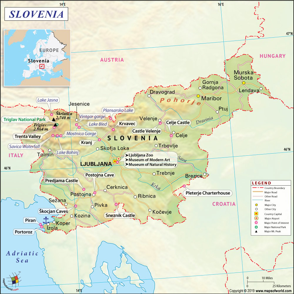
Slovenia Map

- Neighboring Countries - Croatia, Austria, Hungary, Italy, Slovakia
- Continent And Regions - Europe Map
- Other Slovenia Maps - Where is Slovenia, Slovenia Blank Map, Slovenia Road Map, Slovenia Rail Map, Slovenia River Map, Slovenia Political Map, Slovenia Physical Map, Slovenia Flag
Explore the maps of Slovenia to learn everything you want to know about this country. Learn about the location of Slovenia on the world map. The official symbol, flag, geography, climate, postal/area/zip codes, time zones, etc. Check out the history, significant states, provinces/districts, & cities, most popular travel destinations and attractions, the capital city’s location, facts and trivia, Top 10 FAQs (Frequently Asked Questions), and many more.
About Slovenia
Slovenia, officially known as the Republic of Slovenia, is a country in Central and Southeastern Europe. The country touches the Alps and borders the Mediterranean Sea. The 15th Meridian east almost corresponds to the middle line of the country in an east-west direction. The country has been historically at the crossroads of Slavic, Germanic, and Roman cultures and languages. The territory of Slovenia has been part of many different states like the Roman Empire, the Byzantine Empire, the Kingdom of Hungary, the Republic of Venice, the Austro-Hungarian Empire, and more. Check key facts of Slovenia for more interesting facts about Slovenia.
Flag of Slovenia
The present flag of Slovenia was officially adopted on 25 June 1991. The design of the flag consists of three equal horizontal bands of white color (top), blue (middle), and red color (bottom). The coat of arms of Slovenia is featured on the upper hoist side of the flag, centered in the white and blue bands.
Slovenia Location
Slovenia Location Map shows the exact location of Slovenia on the world map. This location map depicts the boundaries of this country, neighboring countries, and oceans. The country shares its boundary with Austria to the north, Italy to the west, Hungary to the northeast, Croatia to the southeast, and the Adriatic Sea to the southwest. The Latitude and Longitude extent of Slovenia is 45. and 47. N Latitude and 13. and 17. E Longitude in Europe. One can check this Latitude and Longitude Map of Slovenia for more information.
Slovenia Capital
The capital city of Slovenia is Ljubljana, the largest city in the country. Ljubljana is the country’s economic, political, cultural, educational, and administrative center. The city is situated in the Ljubljana Basin in Central Slovenia between the Alps and Carst.
Time Zones in Slovenia
Slovenia uses only a one-time zone; Central European Standard Time (CET) is one hour ahead of UTC (coordinated universal time), that is, UTC+1. Slovenia observes daylight saving time as Central European Summertime (CEST), where the clocks are switched forward by 2 hours in summer (UTC +2).
Slovenia Geography
The physical map of Slovenia has revealed all the details about the country’s physical features, including mountain peaks, rivers, and lakes. The country is mostly mountainous and forested, covering an area of 20,271 square kilometers (7,827 sq mi). The average height of Slovenia is 557 m (1827 ft) above sea level, and the highest peak is Triglav (2,864 m or 9,396 ft). Four significant European geographic regions meet in Slovenia. These European geographic regions are the Alps, the Dinarides, the Pannonian Plain, and the Mediterranean Sea.
Slovenia Climate
The climatic conditions of Slovenia are predominantly characterized by the temperate continental climate, with the exception of the Julian Alps in the northwest and the Slovene Littoral region. The Julian Alps have an alpine climate. Sub-Mediterranean climate prevails in northern extensions of the Dinaric Alps that traverse the country in a northwest-southeast direction.
Slovenia Major Cities
Slovenia Cities Map reveals useful details, the capital city, and administrative divisions. The major cities of Slovenia are:
- Ljubljana (capital)
- Maribor
- Celje
- Kranj
- Velenje
- Piran
- Koper
Regions in Slovenia
Slovenia is divided into twelve statistical regions, which are the first-level administrative subdivisions of the country. These statistical regions (NUTS-3 level) are further grouped into two cohesion regions (NUTS-2 level) which are:
- Eastern Slovenia
- Western Slovenia
Slovenia Airports
There are a total of three International Airports in Slovenia. The country has three civil IFR airports, one military air base, 12 VFR-only airports, and 40 airstrips. The three main Airports in Slovenia are:
- Ljubljana Joze Pucnik Airport
- Maribor Edvard Rusjan Airport
- Portoroz Airport
Slovenia Postal or ZIP Codes
Postal codes in Slovenia consist of four digits written without separator characters. Postal codes are numerical strings that form part of a postal address in Slovenia. The first digit represents the region, and the last three represent the individual post office.
Slovenia Travel
Slovenia is known for its diverse landscape, 20th-century architecture, and picturesque beauty. Some of the most popular tourist destinations of Slovenia are:
- Bled and Lake Bled
- Postojna Cave
- Lipica
- Piran
- Skocjan Caves
- Velika Planina Plateau
- The Logar Valley
- Maribiot
Top FAQs on Slovenia
FAQ #1:How big is Slovenia?
Ans: Slovenia covers a total area of 20,273 km2.
FAQ #2: Is Slovenia in the EU?
Ans: Slovenia became a full member of the European Union on 1 May 2004.
FAQ #3 What language is spoken in Slovenia?
Ans: The official language of Slovenia is Slovene, a South Slavic language.
FAQ #4:Is Slovenia in NATO?
Ans: Slovenia became part of NATO on 29 March 2004.
 Wall Maps