- DRC Cities - Kinshasa
- Neighboring Countries - Angola, Republic of the Congo, Central African Republic, South Sudan, Uganda, Rwanda, Burundi, Tanzania, Zambia
- Continent And Regions - Africa Map
- Other Democratic Republic of the Congo Maps - DRC Map, Where is DRC, DRC Blank Map, DRC Road Map, DRC Rail Map, DRC River Map, DRC Political Map, DRC Flag
In Central Africa, the Democratic Republic of the Congo is formerly known as zaire. The country is located in Sub-Saharan Africa. It shares its boundary in the north with the Central African Republic, in the northwest with the Republic of Congo, in the northeast with South Sudan, and in the east with Burundi, Uganda, Tanzania, and Rwanda. To the southeast and south by Zambia, to the southwest by Angola, and to the west by Cabinda Province exclave of Angola and the South Atlantic Ocean.
Democratic Republic of Congo Physical Features
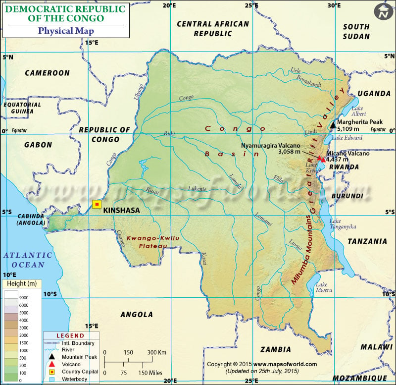
One can point out the latitudes and longitudes of the country on the map along with international boundaries and neighboring countries. The Democratic Republic of Congo lies between latitudes 5. N. and 15. S and longitudes 15. E and 30.E. The map also highlights the capital of the Democratic Republic of Congo, Kinshasa, in a red-yellow dot and is beneficial for school presentations and other purposes. The country’s topographic region includes:
Congo Basin
The Central Congo Basin region forms the core region of the country. This basin constitutes most of the Democratic Republic of Congo Territory. The area is a vast rolling plain with an average height of about 1,700 feet (520 meters) above sea level. The lowest point occurs at Lake Mai-Ndombe at an average elevation of about 1,109 feet, and the highest point occurs at the hills of Zongo and Mobayi-Mbongo at about 2,296 feet (700 meters).
Rift Valley and Mountain Ranges in DRC
The area is the western arm of the East African Rift Valley System. The north-south rift valley forms the country’s eastern border. This region is rugged and has high peaks. The region has chains of the mountain. The Mitumba Mountains rise along the Western Rift Valley, about 9,800 feet (2,990). The Ruwenzori range between Lakes Edward and Albert lies along the Ugandan border. The country’s highest elevation is Margherita’s peak at the height of 16,763 feet (5,109 meters). The Virunga Mountains across the Western Rift Valley are volcanic.
High plateaus and Coastal plains
High plateaus border almost all sides of the Central Basin. Ubangi-Uele Plateaus in the north form the divide between Congo and Nile river basins and separate the central basin from the plains of Lake Chad. These plateaus have an elevation between 3000 and 4000 feet. In the south, the plateaus start from the lower terraces of Lunda and Lulua river valley and rise towards the east. In the southeast, there are ridges of the plateaus of Katanga. They include Mitumba at 4,920 feet, Hakansson at 3,610 feet (1,100 meters), and Kundelungu at 5,250 feet. Katanga plateau extends far north and has Manika Plateau, the Bia Mountains, the Kibara, and the high plains of Marangu.
There is a coastal plateau zone in the far west which includes crystal mountains and the hill country of Mayombe. A narrow coastal plain lies between the Atlantic Ocean and the Cristal Mountains.
Important Rivers and lakes in the Democratic Republic of Congo
Congo River is the country’s principal river, which rises in the high Katanga Plateaus and flows north and then south in an arc shape, crossing the Equator twice. The important lakes of the country include Tumba Mai-Ndombe, and major tributaries are Aruwimi, Lomami, and the Ubangi river of Kasai River.
Physical Map of Neighbouring Countries

 DRC Facts