- Panama Cities - Chitre, Colon, Cristobal, David, La Palma, Panama City, Penonome, Portobelo, Santiago, Vacamonte
- Neighboring Countries - Costa Rica, Nicaragua, Colombia
- Continent And Regions - North America Map, Americas Map
- Other Panama Maps - Panama Map, Where is Panama, Panama Blank Map, Panama Road Map, Panama Rail Map, Panama Cities Map, Panama Physical Map, Panama Flag
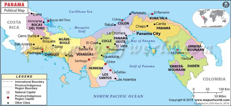
Panama’s Political Map features the important cities, states, and state capitals of Panama. It is a Central American country that is situated between Costa Rica and Colombia. The capital city of Panama is also Panama. Some of the cities of Panama are El Cope, Almirante, Salud, Canita and Bajo Boquete.
Geography and capital city of Panama
Panama situated on the geographical coordinates of 9° North and 80° West latitude and longitude, is located in Central America. It lies between Costa Rica and Colombia. It borders the North Pacific Ocean and the Caribbean Sea. This country covers an area of about 78,200 sq km. The highest point is Volcan Baru and the coastline of Panama measures 2,490 km.
Panama’s Political Map shows in detail the states, state capitals, and other important cities of Panama. The capital city of Panama is also by the same name. It is located on the geographical coordinates of 8° 58′ North and 79° 32′ West latitude and longitude respectively. It is identifiable on the Political Map of Panama by a red square box.
Panama States
The states of Panama have been marked with separate colors on the Panama Map to easily locate them. Their capital cities are shown by a symbol of the white square box. The states of Panama together with their capitals are given below:
- Bocas Del Toro: Bocas Del Toro
- Chiriqui: David
- Veraguas: Santiago
- Herrerra: Chitre
- Los Santos: Las Tablas
- Cocle: Penonome
- Colon: Colon
- Panama: Panama
- San Blas: El Porvenir
- Darien: La Palma
Panama Cities
Some of the cities of Panama are as follows:
|
|
These cities are marked with black dots on the Panama Political Map.
The Golfo de Los Mosquitos located on the northern side and the Bay of Panama and Gulf of Panama located on the southern side are also clearly shown on the Printable Map of Panama. The water bodies surrounding Panama are depicted on the map in blue color.
| Division | Population | Area(km.²) | Area(mi.²) | Capital |
|---|---|---|---|---|
| Bocas del Toro | 89,269 | 4,601 | 1,777 | Bocas del Toro |
| Chiriqui | 368,790 | 6,477 | 2,501 | David |
| Cocle | 202,461 | 4,927 | 1,902 | Penonome |
| Colon | 204,208 | 4,891 | 1,888 | Colon |
| Darien | 40,284 | 11,091 | 4,282 | La Palma |
| Embera | 8,246 | 4,398 | 1,698 | Cirilo Guainora |
| Herrera | 102,465 | 2,341 | 904 | Chitre |
| Kuna de Madungandi | 3,305 | 2,319 | 895 | |
| Kuna de Wargandi | 775 | 299 | ||
| Kuna Yala | 32,446 | 2,393 | 924 | Nargana |
| Los Santos | 83,495 | 3,805 | 1,469 | Las Tablas |
| Ngabe Bugle | 110,080 | 6,673 | 2,577 | Chichica |
| Panama | 1,385,052 | 9,633 | 3,719 | Panama |
| Veraguas | 209,076 | 10,677 | 4,122 | Santiago (de Veraguas) |
| 14 divisions | 2,839,177 | 75,001 | 28,957 |
