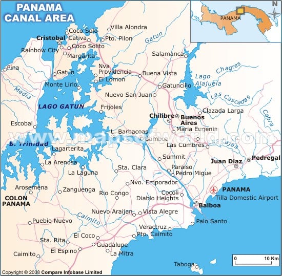
The Panama Canal is a ship canal administered by the Republic of Panama. The 50-mile-long canal connects the Pacific and the Atlantic oceans through the Isthmus of Panama. Considered to be one of the most strategic artificial waterways in the world, it reduces time and shortens the distance of the ships sailing between the east and west coasts of the United States. Ships using this route can shorten their distance by around 8,000 nautical miles or 15,000 km. By using the canal, ships sailing between Europe and East Asia or Australia can trim their journey by as much as 2,000 nautical miles or 3,700 km.
The genesis of the Panama Canal dates back to the 16th century when the Spanish explorer Vasco Nunez de Balboa found out that the Isthmus of Panama was just a narrow land bridge separating the Atlantic and Pacific oceans. This led to a search for a natural waterway to connect the two oceans. However, surveyors decided that the construction of such a ship canal was not feasible. In 1881, France made concerted efforts to build a canal. A French company, led by Ferdinand de Lesseps, began work on the project by digging a canal across Panama, but the excavation work could not take off. However, Eiffel Tower creator Gustave Eiffel was hired to create locks for the canal. Unfortunately, the company that was led by De Lesseps suffered serious financial problems in 1889, and ultimately the venture collapsed.
Later on, French engineer Philippe-Jean Bunau-Varilla, who had earlier been involved in France’s canal projects, called upon American lawmakers to buy French assets in Panama. In 1902, Congress gave permission to buy French assets. However, Panama was a part of Colombia at that time and it refused to ratify an agreement to allow the US to build the canal. Encouraged by the US, Panamanians led a successful revolt against Colombia and declared their independence. Thereupon, John Hay, US Secretary of State, and Bunau-Varilla, who at that time was acting as a representative of Panama’s provisional government, negotiated the Hay-Bunau-Varilla Treaty. This treaty gave the US access to more than 500 square miles and enabled it to construct a canal. Previously under American control, in 1999, the ownership of the Panama Canal was taken over by the government of Panama. It is now operated by the Panama Canal Authority.
Important facts and trivia
- The highest toll was paid by a Disney cruise ship in 2008. This amounted to $330,000.
- It has been estimated that every year between 12,000 and 15,000 ships pass the Panama Canal.
- Fluorescent lighting was installed in 1963. This enabled the canal to be operated 24 hours a day.
- In 1994, the American Society of Civil Engineers named the Panama Canal one of the Seven Wonders of the Modern World.
- Ships traveling between New York and San Francisco save 7,872 miles by using the Panama Canal. Otherwise, they would have to go around Cape Horn.
Panama Canal which links the Atlantic Ocean and the Pacific Ocean has proved to be a turning point in the history of the isthmus of Panama. Know in detail about this canal that has made Panama a prosperous country.

 Panama Facts