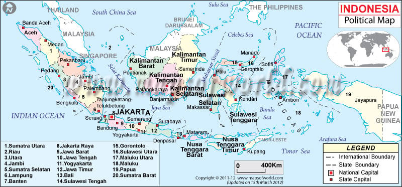
- Indonesia Provinces - Aceh, Bali, Bangka-Belitung, Banten, Bengkulu, Gorontalo, Jakarta Raya, Jambi, Jawa Barat, Jawa Tengah, Jawa Timur, Kalimantan Barat, Kalimantan Selatan, Kalimantan Tengah, Kalimantan Timur, Kalimantan Utara, Kepulauan Riau, Lampung, Maluku Utara, Maluku, Nusa Tenggara Barat, Nusa Tenggara Timur, Papua, Riau, Sulawesi Barat, Sulawesi Selatan, Sulawesi Tengah, Sulawesi Tenggara, Sulawesi Utara, Sumatera Barat, Sumatera Selatan, Sumatera Utara, West Papua, Yogyakarta
- Neighboring Countries - Singapore, Malaysia, Papua New Guinea, Australia
- Continent And Regions - Asia Map
- Other Indonesia Maps - Indonesia Map, Where is Indonesia, Indonesia Blank Map, Indonesia Road Map, Indonesia Rail Map, Indonesia River Map, Indonesia Cities Map, Indonesia Physical Map, Indonesia Flag
A violet line is used to mark the provincial boundaries, which form the archipelago. The political map of Indonesia also displays its location on the world map. The international boundary is drawn by a black line. The printable map of Indonesia has used symbols like red stars and green squares to point to the country’s capital and province capitals.
Location of Indonesia and Geographical Coordinates
The archipelagic state is located between the Indian Ocean and the Pacific Ocean in Southeastern Asia. The geographical coordinates of the country are 5° South latitude and 120° East longitude. The total area of the country is 1,919,440 square kilometers.
From the total domain, the land area covered is 1,826,440 square kilometers and the area covered by water bodies is 93,000 square kilometers. 54,716 kilometers make up the land periphery of Indonesia. Punchak Jaya situated at a height of 5,030 meters is calculated as the highest point of the country while the Indian Ocean is the lowest point.
Province Boundaries and Capitals
The province boundaries are marked with a violet line to differentiate them from each other. Green squares on the map of Indonesia denote the provincial capitals of the archipelago.
Country Capital
The country’s capital of Indonesia is Jakarta. The city is pointed with a red dot on the Indonesia map. The latitudinal and longitudinal extent of the city is 6° 10′ 28” South and 106 49′ 46” East. Jakarta is situated 3 meters above sea level. Some of the nearby cities are Kebonjae, Pecenongan, Tanah Nyonya, Ketopang, Dongkelan, Gambir and Kebonklapa. The city can be accessed through four airports, which are:
- Halim Perdanakusuma International Airport
- Soekarno Hatta International Airport
- Pondok Cabe Airport
- Budiarto Airport
Indonesia border with following countries:
Neighboring countries of Indonesia are as follows:
- Philippines Political Map
- Andaman and Nicobar Islands
- Australia Political Map
- Singapore Political Map
- Palau Map
8.6 magnitude Earthquake on the coast of Indonesia and Tsunami Warning in Southeast Asia, should the world invest in building a mechanism to predict Earthquakes?
Provinces of Indonesia |
|---|
| Province | Population | Area(km.²) | Area(mi.²) | Capital | Reg |
|---|---|---|---|---|---|
| Aceh Map | 3,930,905 | 51,937 | 20,053 | Banda Aceh | SM |
| Bali Map | 3,151,162 | 5,633 | 2,175 | Denpasar | NU |
| Bangka-Belitung Map | 900,197 | 16,171 | 6,244 | Pangkalpinang | SM |
| Banten Map | 8,098,780 | 8,651 | 3,340 | Serang | JW |
| Bengkulu Map | 1,567,432 | 19,789 | 7,641 | Bengkulu | SM |
| Gorontalo Map | 835,044 | 12,215 | 4,716 | Gorontalo | SL |
| Jakarta Raya Map | 8,389,443 | 664 | 256 | Jakarta | JW |
| Jambi Map | 2,413,846 | 53,437 | 20,632 | Jambi (Telanaipura) | SM |
| Jawa Barat Map | 35,729,537 | 34,597 | 13,358 | Bandung | JW |
| Jawa Tengah Map | 31,228,940 | 32,549 | 12,567 | Semarang | JW |
| Jawa Timur Map | 34,783,640 | 47,922 | 18,503 | Surabaya | JW |
| Kalimantan Barat Map | 4,034,198 | 146,807 | 56,682 | Pontianak | KA |
| Kalimantan Selatan Map | 2,985,240 | 43,546 | 16,813 | Banjarmasin | KA |
| Kalimantan Tengah Map | 1,857,000 | 153,564 | 59,291 | Palangkaraya | KA |
| Kalimantan Timur Map | 2,455,120 | 230,277 | 88,910 | Samarinda | KA |
| Kepulauan Riau Map | Tanjung Pinang | SM | |||
| Lampung Map | 6,741,439 | 35,384 | 13,662 | Bandar Lampung | SM |
| Maluku Map | 1,205,539 | 46,975 | 18,137 | Ambon | MA |
| Maluku Utara Map | 785,059 | 30,895 | 11,929 | Ternate | MA |
| Nusa Tenggara Barat Map | 4,009,261 | 20,153 | 7,781 | Mataram | NU |
| Nusa Tenggara Timur Map | 3,952,279 | 47,351 | 18,282 | Kupang | NU |
| Papua Map | 2,220,934 | 365,466 | 141,107 | Jayapura | IJ |
| West Papua Map | Manokwari | IJ | |||
| Riau Map | 4,957,627 | 94,560 | 36,510 | Pekanbaru | SM |
| Sulawesi Barat Map | Mamuju | SL | |||
| Sulawesi Selatan Map | 8,059,627 | 62,365 | 24,079 | Makassar | SL |
| Sulawesi Tengah Map | 2,218,435 | 63,678 | 24,586 | Palu | SL |
| Sulawesi Tenggara Map | 1,821,284 | 38,140 | 14,726 | Kendari | SL |
| Sulawesi Utara Map | 2,012,098 | 15,273 | 5,897 | Manado | SL |
| Sumatera Barat Map | 4,248,931 | 42,899 | 16,563 | Padang | SM |
| Sumatera Selatan Map | 6,899,675 | 93,083 | 35,940 | Palembang | SM |
| Sumatera Utara Map | 11,649,655 | 73,587 | 28,412 | Medan | SM |
| Yogyakarta Map | 3,122,268 | 3,186 | 1,230 | Yogyakarta | JW |
| 33 divisions | 206,264,595 | 1,890,754 | 730,024 |
 Wall Maps