- Neighboring Countries - Solomon Islands
- Continent And Regions - Oceania Map
- Other Papua New Guinea Maps - Papua New Guinea Map, Where is Papua New Guinea, Papua New Guinea Blank Map, Papua New Guinea Road Map, Papua New Guinea River Map, Papua New Guinea Cities Map, Papua New Guinea Flag
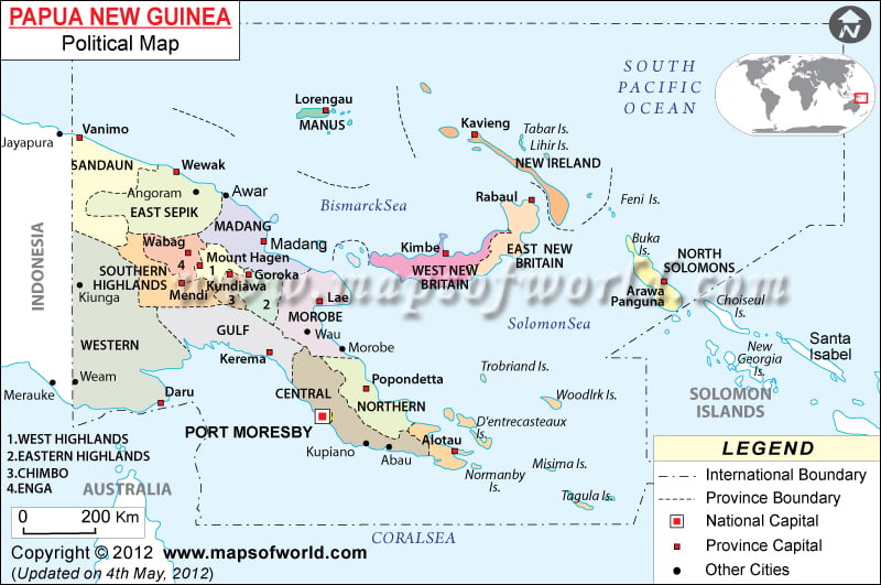
Papua New Guinea Political Map shows the important locations, cities and islands of Papua New Guinea. Port Moresby is the national capital and can be accessed from the airport of Port Moresby Jacksons International.
A section of the eastern half of New Guinea Island is also a part of Papua New Guinea.
Position of Papua New Guinea
Papua New Guinea Political Map shows that it is a group of islands that is located between the South Pacific Ocean and the Coral Sea. It also consists of a part of the eastern half of New Guinea Island. Papua is located on the latitude of 6° South and longitude of 147° East. The total area covered by this group of islands is 462,840 sq km. the coastline measures 5,152 km.
Location of Papua New Guinea
Some of the important locations of Papua New Guinea as shown on the Papua Map are:
|
|
Capital city of Papua New Guinea
Port Moresby located on the geographical coordinates of 9° 30′ South and 147° 10′ East latitude and longitude, is the capital of Papua New Guinea. It is highlighted on the Papua New Guinea Political Map by a red square box. Port Moresby Jacksons International Airport is located here
The Bismarck Sea and the Solomon Sea separating the island of West New Britain is clearly shown on the Political Map of Papua New Guinea.
Papua New Guinea Cities
The cities are symbolized by black dots on the Printable Map of Papua New Guinea. Some of the major cities of Papua New Guinea are:
|
|
Papua New Guinea Islands
The islands of Papua New Guinea are given below:
|
|
| Provinces | Population | Area(km.²) | Area(mi.²) | Capital |
|---|---|---|---|---|
| Bougainville | 175,160 | 9,300 | 3,590 | Buka |
| Central | 183,983 | 29,500 | 11,390 | Port Moresby |
| Chimbu | 259,703 | 6,100 | 2,360 | Kundiawa |
| Eastern Highlands | 432,972 | 11,200 | 4,320 | Goroka |
| East New Britain | 220,133 | 15,500 | 5,980 | Kokopo |
| East Sepik | 343,181 | 42,800 | 16,530 | Wewak |
| Enga | 295,031 | 12,800 | 4,940 | Wabag |
| Gulf | 106,898 | 34,500 | 13,320 | Kerema |
| Hela | Tari? | |||
| Jiwaka | Minj? | |||
| Madang | 365,106 | 29,000 | 11,200 | Madang |
| Manus | 43,387 | 2,100 | 810 | Lorengau |
| Milne Bay | 210,412 | 14,000 | 5,410 | Alotau |
| Morobe | 539,404 | 34,500 | 13,320 | Lae |
| National Capital District | 254,158 | 240 | 90 | Port Moresby |
| New Ireland | 118,350 | 9,600 | 3,710 | Kavieng |
| Northern | 133,065 | 22,800 | 8,800 | Popondetta |
| Sandaun | 185,741 | 36,300 | 14,020 | Vanimo |
| Southern Highlands | 546,265 | 23,800 | 9,190 | Mendi |
| Western | 153,304 | 99,300 | 38,340 | Daru |
| Western Highlands | 440,025 | 8,500 | 3,280 | Mount Hagen |
| West New Britain | 184,508 | 21,000 | 8,110 | Kimbe |
| 22 divisions | 5,190,786 | 462,840 | 178,710 |
 Wall Maps
 Facts about Papua New Guinea