- Cameroon Cities - Yaounde
- Neighboring Countries - Nigeria, Chad, Central African Republic, Equatorial Guinea, Gabon, Republic of the Congo
- Continent And Regions - Africa Map
- Other Cameroon Maps - Cameroon Map, Where is Cameroon, Cameroon Blank Map, Cameroon Road Map, Cameroon Rail Map, Cameroon River Map, Cameroon Political Map, Cameroon Flag
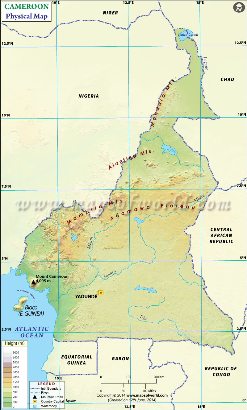
Cameroon, officially known as the Republic of Cameroon, is a triangular country in the west-central African Continent. It shares its boundary with the Central African Republic to the east, Chad to the northeast, Nigeria to the north and west, and the Republic of the Congo, Gabon, and Equatorial Guinea to the south. The map also highlights the capital of Cameroon Yaounde in a red, and yellow dot and is very useful for schoolwork, presentations, and other purposes.
Cameroon is located at a strategic position at the crossroads between Central and West Africa, also known as the hinge of Africa. The country has 475,442 square kilometers (183,569 sq mi) and has control over 13 nautical miles of the Atlantic Ocean. This physical map depicts the latitudinal extent 1. N to 13. N and longitudinal extent between 8. E to 17. E. Based on topographic, climatic, and vegetation features, Cameroon is divided into the following geographic zones:
The Coastal plains in Cameroon
The coastal plain region extends inland from the Gulf of Guinea about 20 to 80 kilometers and has an average height of about 90 meters (295 ft). This area is part of the Cross-Sanaga-Bioko forests and is densely forested.
South Cameroon plateau
These plateaus rise from the coastal plain to an average height of 500-600 meters (2,133 ft). This plateau lies southeast of the Cameroon range and south of the Adamawa plateau. It is a dominant geographical pattern of the country. A peneplain characterizes this plateau in the southwest. This region is part of the Atlantic Equatorial coastal forests ecoregion and is dominated by tropical forests.
Cameroon range
Along with the western border of the country, there are mountain ranges. An irregular chain of mountains, plateaus, and hills extends from Mount Cameroon to Lake Chad. The region includes Mambilla Highlands, Bamileke, and Bamenda. There is volcanic Cameroon mountain Mountain which has the highest point in West Africa at 13,451 feet (4,100 m).
Adamaoua Highlands (Adamawa Plateau)
This plateau region stretches through the north-central Cameron to the Central African Republic. This region forms the barrier between north and south and has an average height of about 1,000 m (3,400 ft).
The drainage pattern of Cameroon
The drainage system of Cameroon follows four patterns generally:
- In the south, essential rivers are Nyong, Sanaga, Ntem, and Wouri, which flow directly into the Gulf of Guinea.
- The Kadei and Dja rivers drain into the Congo River in the southeast direction.
- Benue River flows in the west and north direction and empties into the Niger river in northern Cameroon.
- The logone, which Cameroon shares with three neighboring countries, flows into Lake Chad in the north direction.

 Cameroon Education System