logo


Cameroon Latitude and Longitude Map

Cameroon's latitude and longitude is 6° 00' N and 12° 00' E . Below is the map of Cameroon showing major towns, roads, airports with latitudes and longitudes plotted on it.
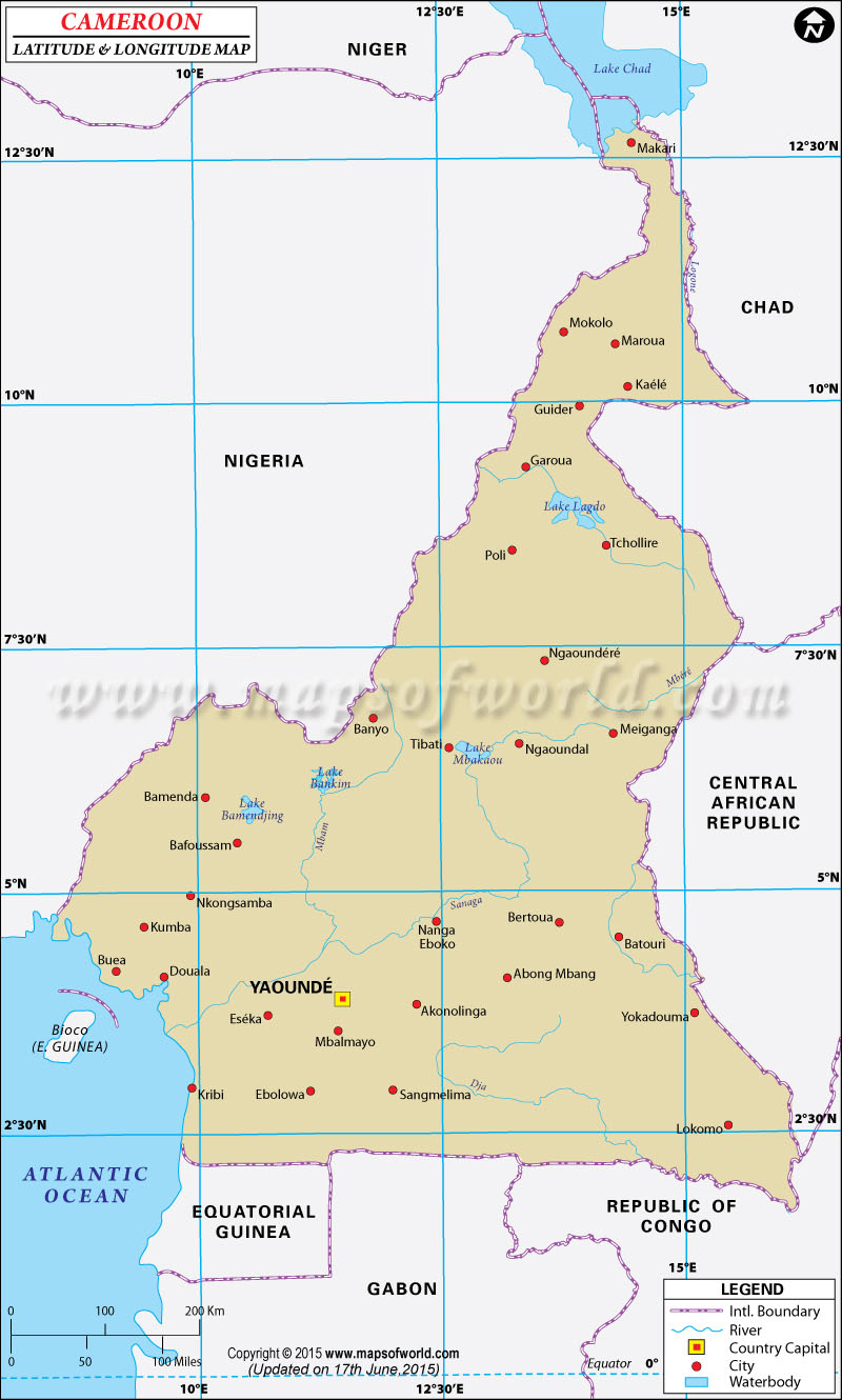
Cameroon Latitude and Longitude Map Niger Lat Long Chad Lat Long Central African Republic Lat Long Congo Lat Long Gabon Lat Long Equatorial Guinea Lat Long Equatorial Guinea Lat Long Nigeria Lat Long
Description : Find Cameroon latitude and longitude map showing comprehensive details including cities, roads, towns, airports and much more. Disclaimer
×

Disclaimer  :  All efforts have been made to make this image accurate. However MapSherpa, Inc, its directors and employees do not own any responsibility for the correctness or authenticity of the same.


Search For Latitude & Longitude Map

By Country

Or

Latitude

Longitude

Or

Area

* Put South & West values with minus ( - ) sign.

The Latitude and Longitude of Cameroon is 6° 00' N and 12° 00' E. The latitude of this country suggests its position in the northern hemisphere and its proximity to the great circle. This country of Cameroon is encompassing the Bright of Biafra, which is located between the tropical regions of Nigeria and Guinea. The land of Cameroon occupies 475,400 square kilometer area.

The soil of Cameroon is enriched with variety of natural resources which owes a lot to its particular latitude and longitude. The climatic condition in Cameroon alters with altitude and locations. In the coastal area the weather is generally sultry and humid while towards north this is significantly warm and dry. Yaoundé the state capital of Cameroon is endowed with 3° 52' N Latitude and 11° 32' E Longitude . The standard time of this country denotes UTC+1.

Latitude and Longitude of Cameroon

LocationLatitudeLongitude
04°00'N13°08'E
Adamaoua, Massif de L',07°20'N12°20'E
Banyo06°52'N11°45'E
Batouri04°30'N14°35'E
Bertoua04°30'N13°45'E
Betare Oya05°40'N14°05'E
Cameroun, Mt.04°13'N09°10'E
Djoum02°41'N12°35'E
Douala04°00'N09°45'E
Ebolowa02°55'N11°10'E
foumban05°45'N10°50'E
Garoua09°19'N13°21'E
Garwa/Garoua09°19'N13°21'E
Adamawa Highlands/Adamaoua, Massif de L',07°20'N12°20'E
 
LocationLatitudeLongitude
Kousseri12°00'N14°55'E
Kribi02°57'N09°56'E
Kumba04°36'N09°24'E
Limbe04°01'N09°10'E
Maroua10°40'N14°20'E
Mbalmayo03°33'N11°33'E
Nanga-Eboko04°41'N12°22'E
Ngoundere07°15'N13°35'E
Nkongsabma04°55'N09°55'E
Sanaga3°35'N9°38'E
Sangmelima 2°57'N12°1'E
Yaounde3°50'N11°35'E
Yokadouma3°26'N14°55'E
Yoko3°26'N14°55'E

Last Updated on: November 9th, 2017