- Neighboring Countries - Namibia, Zambia, Zimbabwe, South Africa, Angola
- Continent And Regions - Africa Map
- Other Botswana Maps - Botswana Map, Where is Botswana, Botswana Blank Map, Botswana Road Map, Botswana Rail Map, Botswana River Map, Botswana Cities Map, Botswana Political Map, Botswana Flag
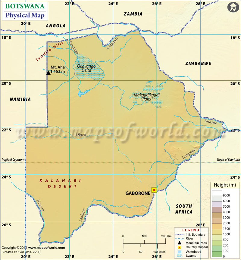
Botswana is topographically flat, with almost 70 percent of its territory belonging to the Kalahari Desert. It shares a boundary with Namibia to the west and north, South Africa to the south, Zambia, and Zimbabwe to the northeast. This interactive Botswana Physical Map depicts topography on an original scale. This map also elaborates on plateaus, rivers, swamps, mountain peaks, plains, desert areas, and other topographic features of Botswana. Botswana’s capital Gaborone is also marked on the map. The latitudinal and longitudinal extent of Botswana is 17. and 27. South, and 20. and 30. E.
Botswana Physical Features
Botswana comprises a total area of 581,730 km2, of which 566,730 km2 of the island. The topography of Botswana is majorly flat, with an average of around 1000-1100 m. The highest point is Tsodilo Hills at 1489 m, and the lowest point is a junction of the Limpopo and Shashe Rivers at 513 m. Botswana can be classified into the following natural regions.
Kalahari area with semi-desert and bush Savanna
The Kalahari Desert is a semi-arid sandy savanna covering much of Botswana in the central and southwest. The area with Kgalagadi Transfrontier National park and Central Kalahari Game Reserve is one of the largest continuous sand areas on earth. Quartzite Tsodilo Hills were raised from the dunes in northwest Botswana, with their rock dating back for about 100,000 years.
Okavango Delta and Wetland region
This area is the largest inland delta globally and is marked on the map in the northwest. The Okavango Delta has an area of approximately 15,000 km2. In the rainy season, the site grows over 17,000 km2. This region covers 20% of Botswana’s total area. The Delta is an oasis of lagoons and channels amidst grasslands and Mopane forests. The part where Okavango meets the sand savannah of the Kalahari forms the unique combination of desert and marshland of the Delta with a variety of flora and fauna.
Pan areas with surrounding grass savanna
This region includes the Makgadikgadi salt pan in northeastern Botswana, Nxai pans, and the surrounding savanna area. This area is a large seasonal wetland composed of large component pans, with the largest pan including Sua Pan, Nxai Pan, and Ntwetwe Pan. The area marked on the map is situated in the middle of the dry savanna of Botswana. The pan is one of the largest salt flats in the world.
The river system in Botswana
Significant rivers of Botswana include Limpopo, Shashe, Okavango, and Molopo River. Molopo River creates a geographical border between South Africa and Botswana. Further country can be divided into four drainage regions:
- First is the Chobe River area on the border, along with the Caprivi Strip of Namibia. The region also has a small adjacent swampy area, part of the Zambezi basin.
- Okavango inland drainage basin includes most of the central and north regions of the country.
- Limpo Drainage Basin falls into the easternmost part of the country
- The southern and southwestern regions are mostly dry as compared to other areas. The Molopo River drains the area.
