logo


Botswana Latitude and Longitude Map

Botswana's latitude and longitude is 22° 00' S and 24° 00' E . Below is the map of Botswana showing major towns, roads, airports with latitudes and longitudes plotted on it.
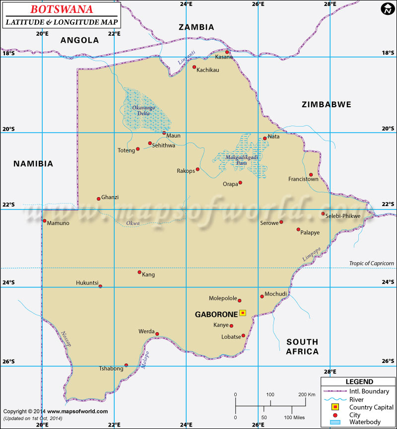
Botswana Latitude and Longitude Map Angola Lat Long Namibia Lat Long South Africa Lat Long Zimbabwe Lat Long Zambia Lat Long
Description : Find Botswana latitude and longitude map showing comprehensive details including cities, roads, towns, airports and much more. Disclaimer
×

Disclaimer  :  All efforts have been made to make this image accurate. However MapSherpa, Inc, its directors and employees do not own any responsibility for the correctness or authenticity of the same.


Search For Latitude & Longitude Map

By Country

Or

Latitude

Longitude

Or

Area

* Put South & West values with minus ( - ) sign.


The main latitude and longitude of Botswana is 22°South and 24°East.
The country of Botswana is an average sized South African country located in the southern Hemisphere. The total area which falls between the latitudes and longitudes of Botswana is 600,370 square kilometer. As the latitudes of Botswana are in close proximity to the equator the climate of the country is mainly temperate in nature having very hot summers. These climatic conditions are responsible for the periodic droughts which causes great suffering to its citizens. The semi arid vegetation is a feature of Botswana.

The latitude and longitude of the capital of Botswana , Gaborone, is 24°40'South and 25°55' East. As the longitude of Botswana is in the east of the Prime Meridian, the time followed is two hours more than UTC. The time zone of Botswana is also termed as 'CAT'.

Latitude and Longitude of Botswana

LocationLatitudeLongitude
Aha Mts., 19°45'S21°00'E
Artesia/Mosomane24°02'S26°19'E
Botletle20°10'S23°15'E
Dibete23°45'S26°32'E
Dinokwe23°29'S26°37'E
Dutlwe23°58'S23°46'E
Foley21°34'S27°21'E
Francistown21°07'S27°33'E
Gaborone24°45'S25°57'E
Gcoveraga19°08'S24°18'E
Ghanzi21°50'S21°34'E
Hukuntsi23°58'S21°45'E
Jwaneng24°45'S24°50'E
Kachikau18°08'S24°26'E
Kalakamati20°40'S27°25'E
Kalkfontein22°04'S20°57'E
Kang23°41'S22°50'E
Kanye24°55'S25°28'E
Kavimba18°02'S24°38'E
Khakhea24°48'S23°22'E
Khomodino22°46'S23°52'E
Khuis26°40'S21°49'E
Khumago20°26'S24°32'E
Kutse21°07'S22°16'E
Kwakhanai21°39'S21°16'E
Lehututu40°50'N75°43'W
Letiahau21°16'S24°00'E
Lethakane21°27'S25°30'E
Lethakeng24°00'S24°59'E
Lobatse25°12'S25°40'E
Likgwabe 24°10'S21°50'E
Mababe Depression18°50'S24°15'E
Madista21°15'S25°06'E
Mahalapye23°01'S26°51'E
MakalaMabedi23°19'S23°51'E
Makarikari/Makgadikgadi Salt pans20°40'S25°45'E
Makgadikgadi, Salt Pans20°40'S25°45'E
Makunda22°30'S20°07'E
Mamuno22°16'S20°01'E
 
LocationLatitudeLongitude
Matapa23°11'S24°39'E
Matima 20°15'S24°26'E
Matlamanyane19°33'S25°57'E
Maun20°0'S2°.26'E
Mochudi24°27'S26°07'E
Molepolole24°28'S25°28'E
Mopipi21°06'S24°55'E
Moshupa24°46'S25°29'E
Mosomane 24°02'S26°19'E
Nata20°14'S26°10'E
Ngami Depression 20°30'S22°46'E
Nojane23°15'S20°14'E
Nokaneng19°40'S22°17'E
Notwane23°35'S26°58'E
Nxau-Nxau18°57'S21°04'E
Okiakwe20°12'S25°17'E
Okavango Delta18°45'S22°45'E
Okavango Swamp/Okavango Delta18°45'S22°45'E
Okwa22°30'S23°0'E
Orapa21°15'S25°30'E
Palapye22°30'S27°07'E
Palla Raod/Dinokwe23°29'S26°37'E
Phala23°45'S26°50'E
Rakops21°01'S24°28'E
Ramotswa24°50'S25°52'E
Selebi-Pikwe21°58'S27°48'E
Selinda Spilway18°35'S23°10'E
Serowe22°25'S26°43'E
Serule21°57'S27°20'E
Sitoti23°15'S23°40'E
Takachu22°37'S21°58'E
Toteng20°22'S22°58'E
Tshesebe 21°51'S27°32'E
Tshwane22°24'S22°1'E
Tsigara20°22'S25°54'E
Tubani24°46'S24°18'E
Tutume20°30'S27°5'E
Ukwi23°29'S20°30'E

Last Updated on: May 26th, 2023