- Zambia Cities - Lusaka
- Neighboring Countries - Zimbabwe, Angola, Tanzania, Botswana, DRC, Namibia
- Continent And Regions - Africa Map
- Other Zambia Maps - Zambia Map, Where is Zambia, Zambia Blank Map, Zambia Road Map, Zambia Rail Map, Zambia River Map, Zambia Flag
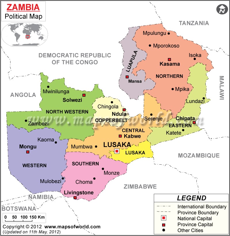
English is the official language of the African country Zambia. In Zambia there are both private and government schools. In Zambia traditional ceremonies are celebrated, which reflects the conventional culture of the country. In the Zambia political map, the features like national capital, boundaries are indicated in a clear format using symbols.
Zambia Political Features
Zambia or Republic of Zambia is a country located in the southern part of African continent. According to history, Zambia was occupied by Khoisan hunters and gatherers during 1st century CE. The geographic coordinates of Zambia are 15° South latitude and 30° East longitude. The country experiences tropical climate. The population of the country according to the census of 2007 was is 11,477,477.
Zambia Capital
The capital of Zambia is Lusaka. Lusaka happens to be the largest city of the country. There are shopping centers, places of attraction at Lusaka. The capital city is served by Lusaka International airport. The 2011 All-African Games would be hosted by Zambia capital Lusaka. The geographic coordinates of Lusaka are 15° 25′ South latitude and 28° 16′ 60″East. The capital city is located at an altitude of 4169 feet. The national capital is indicated in the political map of Zambia by a red square. Some of the cities that are located near Lusaka are Matero, Emmasdale, Turners, Olympia Park, Kabwata and Chipwenupwenu.
Zambia Administrate Divisions
Zambia has been divided into nine provinces. The different Zambia provinces are marked in the political Zambia map by different colors. The provinces of the country are Copperbelt, Central, Luapula, Eastern, Northern, Lusaka, Southern, North-Western and Western. The capitals of the Zambia provinces, which are highlighted in the printable map of Zambia by white squares, are:
|
|
Zambia Boundaries
The international boundaries of Zambia are indicated in the political Zambia map by black lines. The scale of the map is also provided. The neighboring countries are also highlighted in the map of Zambia. The bordering nations of Zambia are:
|
|
Zambia Cities
The major cities of Zambia are indicated in the map by black dots. Some of the Zambia cities are:
|
|
| Province | Population | Area(km.²) | Area(mi.²) | Capital |
|---|---|---|---|---|
| Central | 1,267,803 | 94,394 | 36,446 | Kabwe |
| Copperbelt | 1,958,623 | 31,328 | 12,096 | Ndola |
| Eastern | 1,707,731 | 69,106 | 26,682 | Chipata |
| Luapula | 958,976 | 50,567 | 19,524 | Mansa |
| Lusaka | 2,198,996 | 21,896 | 8,454 | Lusaka |
| Northern | 1,759,600 | 147,826 | 57,076 | Kasama |
| North-Western | 706,462 | 125,826 | 48,582 | Solwezi |
| Southern | 1,606,793 | 85,283 | 32,928 | Livingstone |
| Western | 881,524 | 126,386 | 48,798 | Mongu |
| 9 provinces | 13,046,508 | 752,612 | 290,585 |

 Zambia Tourist Attractions