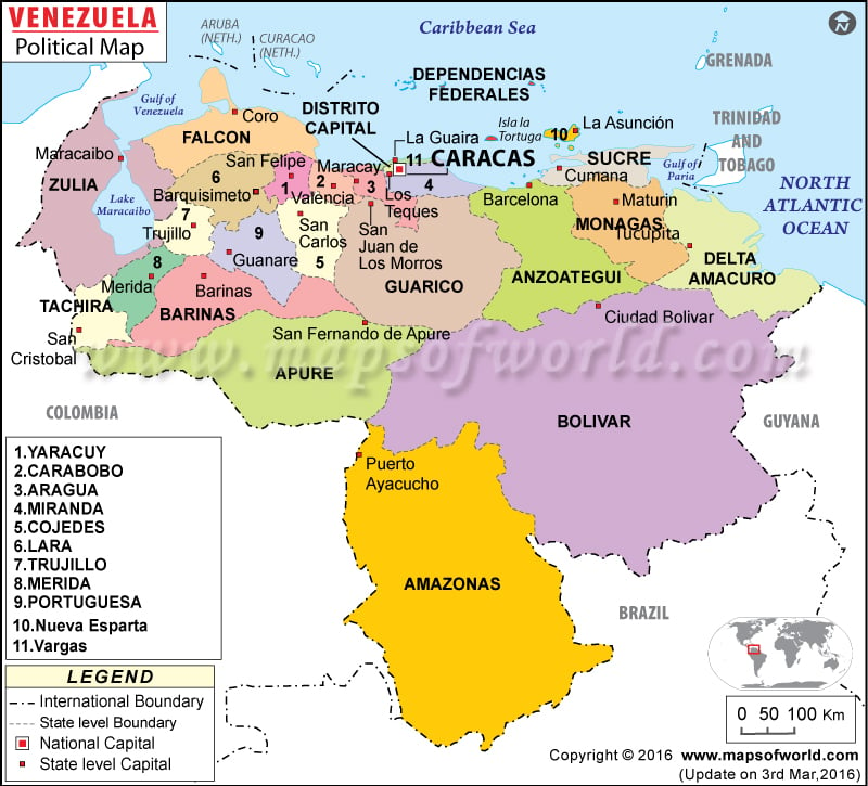
- Venezuela States - Amazonas, Anzoategui, Apure, Aragua, Barinas, Bolivar, Distrito Capital, Carabobo, Cojedes, Delta Amacuro, Dependencias Federales, Monagas, Falcon, Guarico, Lara, Merida, Miranda, Nueva Esparta, Portuguesa, Sucre, Tachira, Trujillo, Vargas, Yaracuy, Zulia
- Neighboring Countries - Brazil, Guyana, Trinidad And Tobago, Colombia
- Continent And Regions - South America, Americas
- Other Venezuela Maps - Venezuela Map, Where is Venezuela, Venezuela Blank Map, Venezuela Road Map, Venezuela Cities Map, Venezuela River Map, Venezuela Physical Map, Venezuela Flag
Venezuela political map helps the browsers to gain effective knowledge about the South American country. The map clearly features the state level boundaries and their capitals for the convenience of the browsers.
The red dot within a square denotes the country capital and the white squares represent the state capitals. The dotted broken lines on the Venezuela map mark the international boundary while the broken lines differentiate the Venezuelan political states.
Location and Geography of Venezuela
The map of Venezuela places the country in the northern part of South America. The bordering coun tries are Guyana, Colombia and Brazil. Venezuela also borders with Caribbean Sea in the north and northeastern part borders with Atlantic Ocean. The latitudinal and longitudinal extent of the country is 8° North and 66° West respectively. The total area of the country is 912,050 square kilometers. 882,050 square kilometers comprise of the land area while 30,000 square kilometers is covered by water bodies. The coastline of the country stretches over an area of 2,800 kilometers. Pico Bolivar situated 5,007 meters above sea level is the highest point of the country while the lowest point is Caribbean Sea.
Capital of Venezuela
The red dot on the map of Venezuela denotes the capital of the country. The geographical coordinates of the city are 10° 30′ North latitude and 66° 55′ West longitude. The city is situated at an altitude of 909 meters above sea level. The city is accessed by four airports namely Simon Bolivar International, Metropolitano, Oscar Machado Zuloaga and generalisimo Francisco De Miranda Ab. The neighboring cities are El Paraiso, La Planicie, Buenos Aires, San Augustin and Puerta Caracas.
| State | Population | Area(Km.²) | Area(Mi.²) | Capital |
|---|---|---|---|---|
| Amazonas | 70,464 | 180,145 | 69,550 | Puerto Ayacucho |
| Anzoategui | 1,222,225 | 43,300 | 16,720 | Barcelona |
| Apure | 377,756 | 76,500 | 29,540 | San Fernando (de Apure) |
| Aragua | 1,449,616 | 7,014 | 2,710 | Maracay |
| Barinas | 624,508 | 35,200 | 13,590 | Barinas |
| Bolivar | 1,214,846 | 238,000 | 91,890 | Ciudad Bolivar |
| Carabobo | 1,932,168 | 4,650 | 1,800 | Valencia |
| Cojedes | 253,105 | 14,800 | 5,710 | San Carlos |
| Delta Amacuro | 97,987 | 40,200 | 15,520 | Tucupita |
| Dependencias Federales | 1,651 | 120 | 50 | |
| Distrito Capital | 1,836,286 | 433 | 170 | Caracas |
| Falcon | 763,188 | 24,800 | 9,580 | (Santa Ana de) Coro |
| Guarico | 627,086 | 64,986 | 25,090 | San Juan (de los Morros) |
| Lara | 1,556,415 | 19,800 | 7,640 | Barquisimeto |
| Merida | 715,268 | 11,300 | 4,360 | Merida |
| Miranda | 2,330,872 | 7,950 | 3,070 | Los Teques |
| Monagas | 712,626 | 28,900 | 11,160 | Maturin |
| Nueva Esparta | 373,851 | 1,150 | 440 | La Asuncion |
| Portuguesa | 725,740 | 15,200 | 5,870 | Guanare |
| Sucre | 786,483 | 11,800 | 4,560 | Cumana |
| Tachira | 992,669 | 11,100 | 4,290 | San Cristobal |
| Trujillo | 608,563 | 7,400 | 2,860 | Trujillo |
| Vargas | 298,109 | 1,497 | 580 | La Guaira |
| Yaracuy | 499,049 | 7,100 | 2,740 | San Felipe |
| Zulia | 2,983,679 | 63,100 | 24,360 | Maracaibo |
| 25 divisions | 23,054,210 | 916,445 | 353,850 |
