- South Carolina Counties - South Carolina County Map, Map of South Carolina Counties,
- Major Cities of South Carolina -
- Neighbouring States - North Carolina, Georgia
- Regional Maps - Map of USA
- Other South Carolina Maps - South Carolina Map, Where is South Carolina, South Carolina Physical Map, South Carolina Lat Long Map, South Carolina Zip Code Map, South Carolina Area Code Map, South Carolina National Parks Map
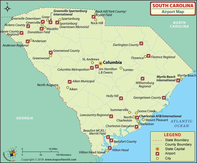
There are 69 airports in South Carolina for the public to use. The airports in South Carolina are well maintained. The South Carolina airports have the latest in aviation technology and provide friendly service.
Airports in South Carolina
The international airports in South Carolina are Charleston International Airport at Charleston, Greenville-Spartanburg International Airport at Greer and the Myrtle Beach International Airport at Myrtle Beach.
The Charleston International Airport at Charleston has a traffic of more than two million passengers annually. The amenities and services provided by the airport include pay phones, ATMs, elevators, a nursery for children, bookstores-cum-news stands, gift shops and VIP rooms.
The airlines that serve at this airport include Continental Airlines, Delta Airlines, United Airlines, Northwest Airlines and US Airways.
Cities
The Greenville- Spartanburg International Airport sees more than a million passengers walk through its gates annually. The airport has a 24 hours ATM service, conference rooms, a gift shop, business centers, restaurants and snack bars, business workstations that are enabled with wireless Internet. This airport in South Carolina is also disabled-friendly and has many facilities for people with disabilities such as TDD phones. The airlines that serve this airport include American Eagle, Delta Airlines, Northwest Airlines, US Airways, Continental Airlines and United Express. Some general aviation airports in South Carolina include Allendale County Airport, Bamberg County Airport, Beaufort County Airport and many more.
One can book the tickets to the above-mentioned airlines online. Some of the airlines offer special fares and discounts too for the online booking of their tickets.
The other important airports in South Carolina include the Rock Hill, Greenville, Cheraw, Anderson, Camden, Columbia, Greenwood, Aiken, Orangeburg, Summerton, Walterboro, and Georgetown.
Some of the city served airports in South Carolina include Charleston International Airport, Columbia Metropolitan Airport, Florence Regional Airport, Greenville-Spartanburg International Airport etc.
Some public-use airports in South Carolina include Hester Memorial Airport, Branhams Airport, Twin Lakes Airport, Holly Hill Airport, Kirk Air Base, Fairview Airport, Dry Swamp Airport, Green Sea Airport, Edgefield County Airport, Clio Crop Care Airport and many more.
Some military airports in South Hamilton include McEntire JNGB, North Air Force Auxiliary Field, Shaw Air Force Base and MCAS Beaufort (Merritt Field). In addition to this, some notable former airports of South Carolina include Lane Airport, which was shut down in 1983, NAS Charleston and Page Field Airport or Marine Corps Airfield, which was closed in 1950s. Two reliever airports in South Carolina include L.B. Owens Airport and Rock Hill/York County Airport (Bryant Field).
Maps of Major Airports in South Carolina
- Charleston International Airport Map
- Myrtle Beach International Airport Map
- Greenville Spartanburg International Airport Map
List of Airports in South Carolina |
|---|
| Airport Name | Airport Code | City | Type | Coordinates |
|---|---|---|---|---|
| Charleston International Airport | CHS | Charleston | International | 32°53′55″N 080°02′26″W |
| Columbia Metropolitan Airport | CAE | Columbia | — | 33°56′20″N 081°07′10″W |
| Florence Regional Airport | FLO | Florence | Domestic | 34°11′07″N 079°43′26″W |
| Greenville-Spartanburg International Airport | GSP | Greer | International | 34°53′44″N 082°13′08″W |
| Hilton Head Airport | HHH | Hilton Head Island | — | 32°13′28″N 080°41′51″W |
| Myrtle Beach International Airport | MYR | Myrtle Beach | International | 33°40′47″N 078°55′42″W |
| Twin Lakes Airport | — | Graniteville | — | 33°38′44″N 081°52′01″W |
| Green Sea Airport | — | Green Sea | — | 34°11′08″N 079°01′14″W |
| Lake City Municipal Airport | — | Lake City | Municipal | 33°51′13″N 079°46′05″W |
 Wall Maps