- Louisiana Counties - Louisiana County Map, Map of Louisiana Counties
- Major Cities of Louisiana - New Orleans, Lafayette, Baton Rouge
- Neighbouring States - Arkansas, Mississippi, Texas
- Regional Maps - Map of USA
- Other Louisiana Maps - Louisiana Map, Where is Louisiana, Louisiana Physical Map, Louisiana Lat Long Map, Louisiana Zip Code Map, Louisiana Area Code Map, Louisiana National Parks Map
Airports in Louisiana
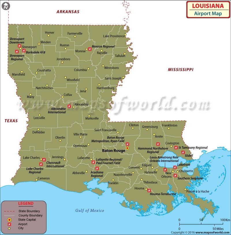
Located in the southern region of the United States, Louisiana is well-connected to the rest of the country through its superior network of airports. There are approximately 69 airports in the state, including Commercial Service – Primary airports, reliever airports, General Aviation airports, public-use airports, military and other notable private-use airports. The Louisiana Airports map shows some of the best airports in the state; let’s get to know more about some that are depicted on the map.
-
Baton Rouge Metropolitan Airport
Baton Rouge Metropolitan Airport is located some seven kilometers north of the central business district of Baton Rouge. The airport is spread over an area of 1,250 acres. Prominent airlines that serve the airport are American Eagle, Delta Air Lines, Delta Connection and United Express.
-
Alexandria International Airport
Alexandria International Airport is a public-use airport located four nautical miles west of the central business district of Alexandria, in Rapides Parish. Operated by the England Authority, also referred to as England Economic and Industrial Development District, the airport has been categorized as a primary commercial service airport by the National Plan of Integrated Airport Systems.
-
Lakefront Airport
As a public-use airport, the Lakefront Airport is located four nautical miles northeast of the central business district of New Orleans, in Orleans Parish. The airport is owned by the Orleans Levee District and has been categorized as a general aviation reliever airport by the National Plan of Integrated Airport Systems for 2011-2015.
-
Esler Regional Airport
Esler Field, or the Esler Regional Airport is a military and public-use airfield located in Rapides Parish, Louisiana, near the City of Pineville. The airport is located about ten nautical miles northeast of the central business district of Alexandria. It is owned by the Louisiana Army National Guard. The airport is also home to the Army Aviation Support Facility.
-
St. Tammany Regional Airport
It is a public-use airport located six nautical miles southeast of the central business district of Covington. It is owned by St. Tammany Parish and has Abita Springs as the nearest town.
-
Minden Airport
This is a public-use airport in Webster Parish. It is located two nautical miles northwest of the central business district. It is owned by the City of Minden and was formerly known as Minden-Webster Airport. The Minden Airport has been assigned MNE by the Federal Aviation Administration (FAA), but lacks a designation by the International Air Transport Association (IATA).
-
Barksdale Air Force Base
As a United States Air Force Base, the Barksdale Air Force Base is located in northwest Louisiana and occupies over 22,000 acres of the land, east of Bossier City. It lies along the southern edge of Interstate Highway 20. Host unit at Barksdale is the 2nd Bomb Wing (2BW), which is the oldest Bomb Wing in the Air Force.
Maps of Major Airports in Louisiana
- Alexandria International Airport Map
- Lakefront Airport Map
- Baton Rouge Metropolitan Airport Map
- St. Tammany Regional Airport Map
- Minden Airport Map
- Esler Regional Airport Map
List of Airports in Louisiana |
|---|
| Airport Name | Code | City | Hub | Enplanements (2015) |
|---|---|---|---|---|
| Louis Armstrong New Orleans International | MSY | Metairie | M | 5,329,711 |
| Baton Rouge Metropolitan, Ryan Field | BTR | Baton Rouge | N | 366,102 |
| Shreveport Regional | SHV | Shreveport | N | 295,257 |
| Lafayette Regional/Paul Fournet Field | LFT | Lafayette | N | 243,840 |
| Alexandria International | AEX | Alexandria | N | 159,252 |
| Monroe Regional | MLU | Monroe | N | 114,170 |
| Lake Charles Regional | LCH | Lake Charles | N | 69,130 |
| Barksdale AFB | BAD | Bossier City | None | 1,567 |
| Acadiana Regional | ARA | New Iberia | None | 880 |
| Lakefront | NEW | New Orleans | None | 270 |
| Southern Seaplane | 65LA | Belle Chasse | None | 250 |
| St Tammany Regional | L31 | Covington | None | 120 |
| Houma-Terrebonne | HUM | Houma | None | 68 |
| Shreveport Downtown | DTN | Shreveport | None | 30 |
| Slidell | ASD | Slidell | None | 29 |
| Hammond Northshore Regional | HDC | Hammond | None | 22 |
| Chennault International | CWF | Lake Charles | None | 1 |
 Wall Maps