US Interstate 12 highway Map
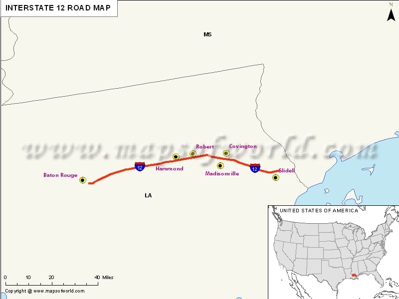
Interstate 12, popularly abbreviated as I-12, is the interstate highway positioned within the US state of Louisiana. It spans across 85.59 miles in an east-west direction from I-10 located in Baton Rouge. It passes through the city of Hammond and serves the smaller cities of Denham Springs and Ponchatoula in addition to St. Tammany Parish cities of Covington and Mandeville.
Extent of I-12 Highway
Considering the west end, US interstate 12 begins three miles east of downtown Baton Rouge in East Baton Rouge Parish at an interchange with the I-10. Prior to departing the Baton Rouge, I-12 intersects a majority of arteries, including LA 3064(Essen Lane) and LA 73(Jefferson Highway) via LA 1068(Drusilla Lane).
The final exist of I-12 is in Baton Rouge that serves as an interchange with LA 3245(O-Neal Lane), which serves as the Ochsner Medical Center and the eastern suburbs. I-12 also intersects LA 1249, which leads to the communities of Bapist and Pumpkin Center.
States and cities along I-12 Highway
- Louisiana
- Baton Rouge
- Mandeville-Covington
- Slidell
Restaurants along Interstate-12 Highway
In order to rejuvenate from a tiring journey, you can head straight to any of these restaurants located near I-12 exists in Louisiana:
- Carrabba’s Italian Grill
- Vincent’s City Club
- Las Palmas Mexican Restaurant
- Chimes Restaurant
Attractions along I-12 Highway
Here is a list of some of the best-known tourist attractions near I-12 exists in Louisiana:
- Sight Seeing Baton Rouge
- Celebration Station
- Louisiana State Archives
- Old South Ballooning Company
- Live Oak Studio LLC
Route of Interstate Highway No.12 |
| State | Entry Point | Exit Point | Length |
|---|---|---|---|
| Louisiana | Baton Rouge, LA | Slidell, LA | 85.59 mi (137.74 km) |
| Total Length | 85.59 mi (137.74 km) |
Last Updated Date: April 15, 2017


