- Kentucky Counties - Kentucky County Map, Map of Kentucky Counties
- Major Cities of Kentucky - Lexington
- Neighbouring States - West Virginia, Virginia, Tennessee, Missouri, Illinois, Indiana, Ohio
- Regional Maps - Map of USA
- Other Kentucky Maps - Kentucky Map, Where is Kentucky, Kentucky Physical Map, Kentucky Lat Long Map, Kentucky Zip Code Map, Kentucky Area Code Map, Kentucky National Parks Map
About Kentucky Airports Map
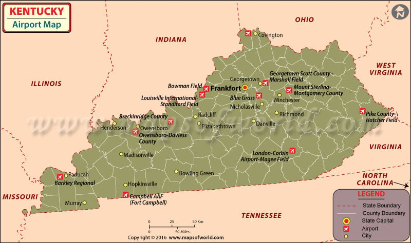
Kentucky Airports Map shows 62 public use Airports in Kentucky including two international airports, the Louisville International Airport and the Cincinnati Northern Kentucky International Airport.
The Louisville International Airport in Kentucky receives almost 4 million passengers annually. The airport has private hangars and a four level parking garage to accommodate the heavy traffic that flows into the airport. The airlines which operate from this airport are: American Airlines, Continental Airlines, Delta Airlines, Midwest Airlines, Northwest Airlink, United Express, Southwest Airlines and US Airways Express.
Cincinnati Northern Kentucky International Airport of Kentucky is one of the busiest airports in Kentucky and its annual traffic exceeds 2 million passengers. The terminals have an underground train shuttle connecting one concourse to another. The airlines from this airport of Kentucky fly to more than 120 cities everyday. The airlines that serve this airport are Air France, American, Continental, Northwest, United, US Airways, and USA 3000.
Blue Grass Airport is a public airport in Fayette County, Kentucky, which is about 4 miles west of downtown Lexington. The airport’s current main terminal building was opened in the year 1977 and the airport covers an area of 911 acres. It also has two runways and is home to the Aviation Museum of Kentucky.
Barkley Regional Airport is situated about 14 miles west of Paducah, in McCracken County, Kentucky. It is owned by the Barkley Regional Airport Authority and is used for general aviation. The airport has been subsidized by the Essential Air Service program and about 100 people are currently employed at the airport. It is interesting to know that the Barkley Regional Airport is the 5th busiest in Kentucky.
Visitors can book tickets online for these airlines at their respective websites. Some airlines also offer travel points for online booking that can be redeemed against the fares of future travels.
Neighboring States :
Indiana, Illinois, Missouri, Ohio, West Virginia, Virginia, Nashville
Maps of Major Airports in Kentucky
- Cincinnati Northern Kentucky International Airport Map
- Louisville International Airport Map
- Blue Grass Airport Map
- Barkley Regional Airport Map
List of Airports in Kentucky |
|---|
| Airport Name | Code | City | Hub | Enplanements (2015) |
|---|---|---|---|---|
| Cincinnati/Northern Kentucky International | CVG | Greater Cincinnati International Airport | M | 3,054,991 |
| Louisville International-Standiford Field | SDF | Louisville | S | 1,640,297 |
| Blue Grass | LEX | Lexington | S | 606,980 |
| Owensboro-Daviess County | OWB | Owensboro | N | 21,951 |
| Barkley Regional | PAH | Paducah | N | 21,027 |
| Campbell AAF (Fort Campbell) | HOP | Fort Campbell | None | 3,488 |
| Bowling Green-Warren County Regional | BWG | Bowling Green | None | 1,155 |
| Pike County-Hatcher Field | PBX | Pikeville | None | 453 |
| Mount Sterling-Montgomery County | IOB | Mount Sterling | None | 12 |
| Bowman Field | LOU | Louisville | None | 8 |
| Georgetown Scott County – Marshall Field | 27K | Georgetown | None | 6 |
| London-Corbin Airport-Magee Field | LOZ | London | None | 6 |
| Breckinridge County | I93 | Hardinsburg | None | 5 |
 Wall Maps