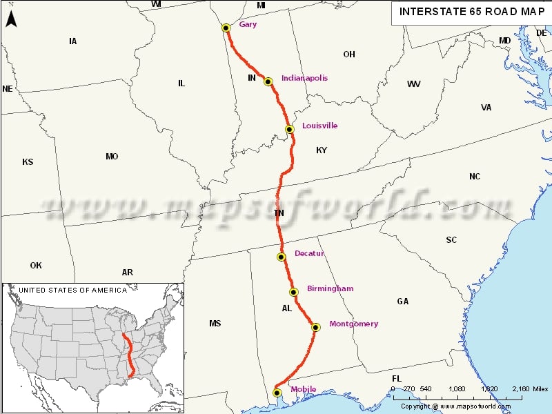
US Interstate-65 Highway Map
The Interstate 65, also written l-65, is a major interstate highway in the central United States. Since the last number of the interstate highway is 5, it is a cross-country highway connecting the Great Lakes with the Gulf of Mexico. The northern terminus of the Interstate 65 is at the interchange with l-90 US 12 and US 20 in Gary, Indiana. The southern terminus of the Interstate 65 is at an interchange with l-10 in Mobile, Alabama.
US Interstate- 65 crosses following States:
- Indiana
- Kentucky
- Tennessee
- Alabama
Major cities along the Interstate 65:
- Gary, Indiana
- Indianapolis, Indiana
- Louisville, Kentucky
- Decatur, Alabama
- Birmingham, Alabama
- Montgomery, Alabama
- Mobile, Alabama
Attractions Along l-65 Highway
US Space & Rocket Center: Take Exit 340B in Huntsville to visit this major attraction in Alabama. See a real Saturn V rocket, missiles, and a real-life Space Shuttle with its external tank and rocket boosters intact.
Ave Maria Grotto: This 4-acre landscaped park in Cullman (Alabama) is known for 125 miniature art reproductions.
Gateway Classic cars: As you drive further north to Tennessee, you come across the Gateway Classic Cars showroom in Louisville.
Discover Great Architecture: Reach further north to visit some interesting places: more-than-a-century-old ice-cream shop, world's largest toilet, and many more
Gas Stations Along Interstate-65 Highway
Hill's Chevron and Merri Mart 315 in Alabama; H&M Phillips 66 and Shelby's l-65 BP in Tennessee, and IGA Express Shell in Kentucky are some of the gas stations you will find along I-65 highway.
Restaurants Along l-65
Pizza Hut in Franklin (Kentucky), Mandarin House Chinese Restaurant in Hoover (Alabama), Las Maracas Mexican Restaurant in Nashville (Tennessee) are some of the popular restaurants you will come across along the highway. Taco Bell in Jeffersonville (Indiana) and Pesto's Italian Restaurant in Louisville (Kentucky) are also worth trying.
Service Stations Along l-65
While Indiana has has two service stations – Chumbley's Auto Repair and Genesis Aut Mechanic – Alabama and Tennessee have P&H Auto Repair & Wholesale and Cobb's Service Center respectively.
Route of Interstate Highway No.65 |
|---|
| State | Entry Point | Exit Point | Length |
|---|
| Alabama | Mobile, AL | Tennessee state line | 367 mi (591 km) |
| Alabama state line, TN | Alabama state line, TN | Kentucky state line, TN | 121.71 mi (195.87 km) |
| Tennessee state line, KY | Tennessee state line, KY | Indiana state line, KY | 137.32 mi (221.00 km) |
| Kentucky state line, IN | Kentucky state line, IN | Gary, IN | 261.27 mi (420.47 km) |
| Total Length | | | 887.30 mi (1,427.97 km) |
Last Updated on: April 15th, 2017


