2K
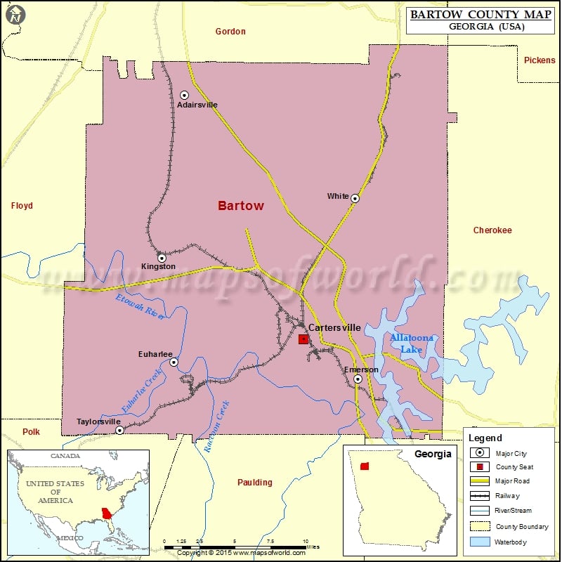
Check this Georgia County Map to locate all the state’s counties in Georgia Map.
Mountain Peaks in Bartow County
| Mountain Peak/Hill | Elevation [Meter] |
|---|---|
| Bee Mountain | 413 |
| Boyd Mountain | 323 |
| Bufford Mountain | 407 |
| Campbell Hill | 357 |
| Cassville Mountain | 337 |
| Collins Mountain | 335 |
| Colston Mountain | 264 |
| Connesena Mountain | 299 |
| Dobbins Mountain | 334 |
| Hanging Mountain | 580 |
| Henderson Mountain | 311 |
| Hodge Mountain | 332 |
| Iron Mountain | 340 |
| Johnson Mountain | 283 |
| Johnson Mountain | 382 |
| Kitchens Mountain | 338 |
| Little Pine Log Mountain | 486 |
| Little Red Mountain | 311 |
| Mullinax Mountain | 324 |
| Perry Mountain | 318 |
| Pine Mountain | 464 |
| Ponders Mountain | 388 |
| Quarry Mountain | 307 |
| Red Mountain | 384 |
| Red Top Mountain | 323 |
| Reservoir Hill | 295 |
| Sharp Top Mountain | 466 |
| Shaw Mountain | 310 |
| Signal Mountain | 402 |
| Snow Springs Mountain | 375 |
| Sproull Mountain | 359 |
| Sugar Hill | 392 |
| Swain Mountain | 328 |
| Turkey Knob | 333 |
| Vineyard Mountain | 412 |
| Walker Mountain | 335 |
| Wolf Cave Mountain | 342 |
| Yellow Jacket Mountain | 276 |
Airports in Bartow County
| Airport Name |
|---|
| Cartersville Airport |
| Etowah Bend Gliderport |
| Etowah Fields Airport |
Cities in Bartow County
| City | Population | Latitude | Longitude |
|---|---|---|---|
| Adairsville city | 4648 | 34.370226 | -84.921455 |
| Cartersville city | 19731 | 34.16311 | -84.800683 |
| Emerson city | 1470 | 34.129706 | -84.744223 |
| Euharlee city | 4136 | 34.143896 | -84.932647 |
| Kingston city | 637 | 34.231973 | -84.944493 |
| Taylorsville town | 210 | 34.085985 | -84.987566 |
| White city | 670 | 34.282401 | -84.747236 |
Golf Courses in Bartow County
| Name of Golf Course | Latitude | Longitude |
|---|---|---|
| Cartersville Country Club-Cartersville | 34.205971 | -84.815106 |
| Green Valley Greens Golf Course-Cartersville | 34.233002 | -84.828062 |
| The General At Barnsley Gardens-Adairsville | 34.30127 | -84.980585 |
| The Plantation Golf Club-Cartersville | 34.09339 | -84.833431 |
 Wall Maps