US Interstate 16 highway Map
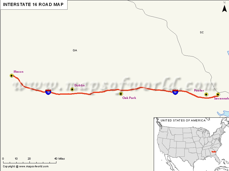
Interstate 16, popularly abbreviated as I-16, is popularly known as Jim Gilis Historic Savannah Parkway. This Interstate Highway is located within the US state of Georgia and carries a hidden designation of State Route 404(SR 404).
I-16 acts as a hurricane evacuation route for Savannah and a range of other coastal areas. While there are some ramps which are still ungated, there is complete east of exist 42 which is a crossover to return all the westbound traffic to the westbound.
Extent of I-16 Highway
Interstate 16 offers part of a high-speed route from the Atlanta to the Golden Isles and Jacksonville in Florida. This US interstate highway also forms a different interstate route that joins Macon with Savannah in the southern Georgia. The sole motive of this route is to link the I-75 with Port of Savannah for easy movement of products.Beyond Macon, I-16 stretches across a rural course south and east across the forested hills in Twiggs County. Additionally, towards the east, I-16 stretches to reach the outskirts of Dublin, the biggest city between Macon and Savannah. Finally, I-16 crosses the Oconee River.
States and cities along I-16 Highway
- Georgia: Macon, Savannah
Restaurants along Interstate-16 Highway
Here is a list of few great restaurants along Interstate-16 Highway:- Nu-Way Weiners
- Luigi’s Bistro
- Ingleside Village Pizza
- Tokyo Alley Restaurant
- Michael’s on Mulberry
Attractions along I-16 Highway
Some of the renowned tourist attractions along I-16 Highway include:- Art on the Avenue
- Macon City Cemetery Rose Hill
- Woodruff House
- Washington Memorial Library
- Cannonball House
Route of Interstate Highway No.16 |
| State | Entry Point | Exit Point | Length |
|---|---|---|---|
| Georgia | Macon, GA | Savannah, GA | 166.81 mi (268.45 km) |
| Total Length | 166.81 mi (268.45 km) |
Last Updated Date: April 15, 2017


