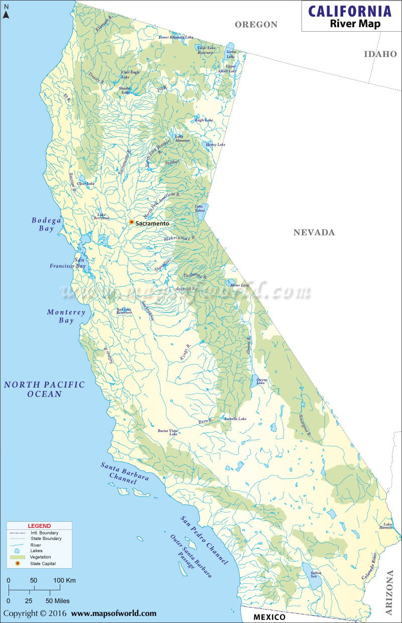
Rivers in California
California falls under the watershed area of the Pacific Ocean. A part of the eastern region of California is under the watershed area of the Great Basin. Sacramento and San Joaquin are the most prominent snow fed rivers of the state.
River Eel, River Klamath, River Salinas and River Russian flow through the coastal region of California. River Merced, River Owens and River Feather are some of the other prominent rivers of the State of California. Most of the rivers of the southern part of California run dry, except during the monsoon season. The Amargosa River of the Death Valley is one of the important rivers of southern California. California has several natural lakes. The California State Map indicates the prominent lakes of the state. Encompassing total area of 969 square kilometer, the Salton Sea of the Imperial Valley is the biggest lake of California. The Salton Sea was formed during the early part of the 1900, when the surplus water of the Colorado River filled up the natural depression of the Imperial Valley. Mono Lake, Owens Lake, Goose Lake, Honey Lake and Tahoe Lake are few of the notable lakes of California.
List of Rivers in California |
|---|
| S.no. | River Name | Area / Length | Location / Source | Mouth |
|---|---|---|---|---|
| 1 | Clear Lake Reservoir | 25,760 acres (10,420 ha) -Surface area | Modoc County, California | NA |
| 2 | Goose Lake | 42 km (26 mi)-Length, 147 sq mi (380 km2)- Surface area | Oregon–California | Endorheic basin, Pit River |
| 3 | Trinity Lake | 2,370 ft (720 m)- Surface | Redding, California | Trinity River |
| 4 | Middle Alkali Lake | NA | NA | NA |
| 5 | Honey Lake | 86 sq mi (220 km2) – Surface area | Great Basin, Lassen County, California, United States | Susan River |
| 6 | Almanor Lake | 13 miles | Plumas County, California | Feather River |
| 7 | Lake Oroville | (10,200 km2) | Oroville East, Butte County, California | Feather River |
| 8 | Lake Tulare | dry bed 130 km (81 mi)- Max. length, dry bed 1,780 km2 (690 sq mi)- Surface area | San Joaquin Valley Kings County, California | NA |
| 9 | Bodega Bay | 4.179 sq mi (10.823 km2) 33.37% (Water Area) | Sonoma County, California, United States | Pacific Ocean |
| 10 | Sacramento | 447 mi (719 km), North-south | Klamath Mountains | Sacramento County, California, Suisun Bay |
| 11 | Mono Lake | 9.321 miles | Mono County, California | tributaries of Mono Lake include Lee Vining Creek, Rush Creek and Mill Creek |
| 12 | Owens Lake | 17.5 mi (28.2 km) | Owens Valley on the eastern side of the Sierra Nevada in Inyo County, California | Owens River, Natural springs and wells |
| 13 | Buena Vista Lake | 60 to 150 square miles | San Joaquin Valley Kern County, California | NA |
| 14 | Santa Barbara Channel | Approximately 130 kilometres (70 nmi) long and averages about 45 kilometres (24 nmi) across | Pacific Ocean (city of Santa Barbara, and west of the city of Ventura ) | Pacific Ocean |
| 15 | San Pedro Channel | NA | NA | NA |
| 16 | Coachella Channel | NA | NA | NA |
| 17 | Saltop Sea | NA | NA | NA |
| 18 | Lake Havasu | 19,300 acres (7,800 ha) – Surface area | Behind Parker Dam on the Colorado River, on the border between California and Arizona | Colorado River |
| 19 | Colorado | 1,450 mi (2,334 km) | La Poudre Pass (Rocky Mountains, Colorado, United States) | Gulf of California |
 Wall Maps