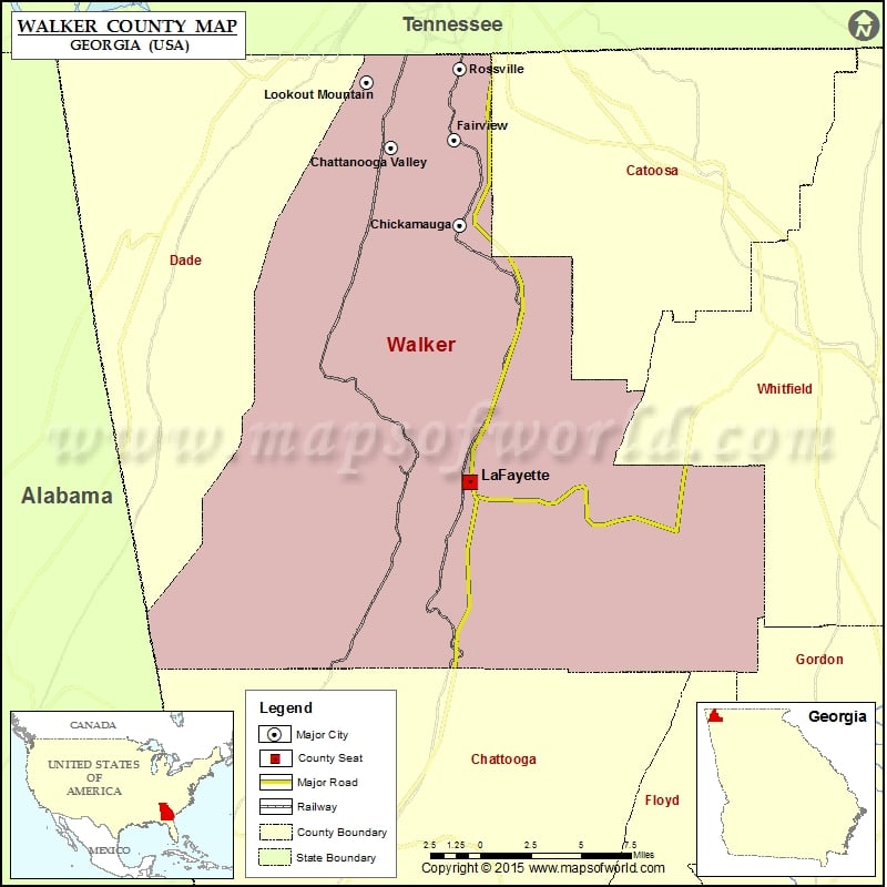
Walker County Map, Georgia
Check this Georgia County Map to locate all the state’s counties in Georgia Map. Mountain Peaks in Walker County Mountain Peak/Hill Elevation [Meter] Gulf Mountain 657 Horn Mountain 405 Mill Creek Mountain 546…
Check this Georgia County Map to locate all the state’s counties in Georgia Map .
Mountain Peaks in Walker County
Mountain Peak/Hill
Elevation [Meter]
Gulf Mountain
657
Horn Mountain
405
Mill Creek Mountain
546
Pigeon Mountain
564
Round Top
641
Snodgrass Hill
274
Strawberry Mountain
419
More Maps of Walker County
Airports in Walker County
Airport Name
Barwick Lafayette Airport
Gibson Field
Hogjowl Airport
Mount Cove STOLport
Cities in Walker County
City
Population
Latitude
Longitude
Chattanooga Valley
3846
34.924092
-85.343244
Chickamauga city
3101
34.874401
-85.289007
Fairview
6769
34.92957
-85.294086
LaFayette city
7121
34.708657
-85.281527
Lookout Mountain city
1602
34.966413
-85.362193
Rossville city
4105
34.974747
-85.289748
Golf Courses in Walker County
Name of Golf Course
Latitude
Longitude
Canyon Ridge Golf Club-Rising Fawn
34.749157
-85.451892
High Point Golf Course-Chickamauga
34.866797
-85.361363
Lafayette Golf Course-La Fayette
34.694453
-85.278884
Lookout Mountain Golf Club-Lookout Mountain
34.961573
-85.35501
National Parks in Walker County
Name of Park
Latitude
Longitude
Chickamauga and Chattanooga NMP
35.001636
-85.352766
Chickamauga and Chattanooga NMP
34.982386
-85.343882
Chickamauga and Chattanooga NMP
34.975216
-85.346128
Chickamauga and Chattanooga NMP
34.919114
-85.254459

 Wall Maps