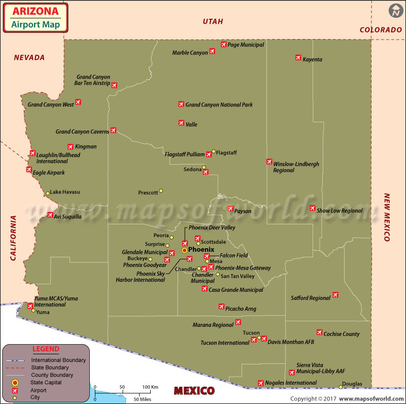
Airport in Arizona
Arizona is the sixth largest state in the United States, and is growing fast. As a result, it attracts many people from around the world. It comes as little surprise then, that airports in Arizona receive a large number of national and international visitors.
What they say is true; Texas’s answer to Silicon Valley, it is a tech town with a hippie heart. With more than 250 music venues, it is nicknamed “Live Music Capital of the World.” Founded in 1839, it was named after the “Father of Texas” – Stephen F. Austin – and is home to the University of Texas.
International Airports in Arizona:
The international airports in Arizona are Laughlin Bullhead International Airport, Phoenix Sky Harbor International Airport, Tucson International Airport, Yuma International Airport, Bisbee Douglas International Airport and Nogales International Airport. Other major airports in Arizona are located in Sierra Vista, Grand Canyon Village, Duncan, Page, Marble Canyon and Kayenta.
Phoenix Sky Harbor International Airport, located in the state’s capital city, is a busy airport, with daily traffic of almost an 110,000 people. 23 airlines have daily operations at this airport.
The Tucson International Airport is another major airport of Arizona, receiving about four million visitors annually. Airlines with operations at this airport are:
Aerolitoral, US Airways, Alaska Airlines, Continental Airlines, United Airlines / Lufthansa Airlines, American Airlines, Delta Airlines / SkyWest, Frontier, Northwest / KLM and Southwest Airlines.
Airports in Arizona are built to a world-class standard and try to provide customers with the best services in the industry. Most of the airlines at Arizona’s airports provide online booking services for convenient traveling.
Maps of Major Arizona Airports
- Phoenix Sky Harbor International Airport Map
- Laughlin Bullhead International Airport Map
- Tucson International Airport Map
- Yuma International Airport Map
- Nogales International Airport Map
- Bisbee Douglas International Airport Map
List of Airports in Arizona |
|---|
| Airport Name | City | Coordinates |
|---|---|---|
| Laughlin/Bullhead International Airport | Bullhead City | 35°09′22″N 114°33′34″W |
| Flagstaff Pulliam Airport | Flagstaff | 35°08′25″N 111°40′09″W |
| Grand Canyon National Park Airport | Grand Canyon / Tusayan | 35°57′08″N 112°08′49″W |
| Phoenix-Mesa Gateway Airport | Mesa | 33°18′28″N 111°39′20″W |
| Page Municipal Airport | Page | 36°55′34″N 111°26′54″W |
| Grand Canyon West Airport | Peach Springs | 35°59′25″N 113°48′59″W |
| Phoenix Sky Harbor International Airport | Phoenix | 33°26′03″N 112°00′42″W |
| Tucson International Airport | Tucson | 32°06′58″N 110°56′28″W |
| Yuma International Airport | Yuma | 32°39′24″N 114°36′22″W |
| Douglas Municipal Airport | Douglas | 31°20′33″N 109°30′23″W |
| Grand Canyon Caverns Airport | Peach Springs | 35.526944, -113.2475 |
| Valle Airport | Valle | 35.649519, -112.14191 |
| Sun Valley Airport | Bullhead City | 35°00′20″N 114°33′54″W |
| Stellar Airpark | Chandler | 33°17′56″N 111°54′56″W |
| Cochise College Airport | Douglas | 31.3711°N 109.6904°W |
| Kearny Airport | Kearny | 33.0474°N 110.9091°W |
| Estrella Sailport | Maricopa | 33°05′07″N 112°09′40″W |
| Pearce Ferry Airport | Meadview | 36°05′36″N 114°02′48″W |
| Eagle Airpark | Mohave Valley | 34°53′17″N 114°36′59″W |
| Marble Canyon Airport | Marble Canyon | 36.8113°N 111.6439°W |
| Pleasant Valley Airport | Peoria | 33.8010°N 112.2498°W |
| Ak-Chin Regional Airport | Phoenix | 32.9908°N 111.9186°W |
| Temple Bar Airport | Temple Bar / Lake Mead | 36°01′14″N 114°20′06″W |
| Tombstone Municipal Airport | Tombstone | 31.6713°N 110.0217°W |
| Grand Canyon Bar 10 Airport | Whitmore | 36.2580°N 113.2311°W |

 Wall Maps