US Interstate 19 highway Map
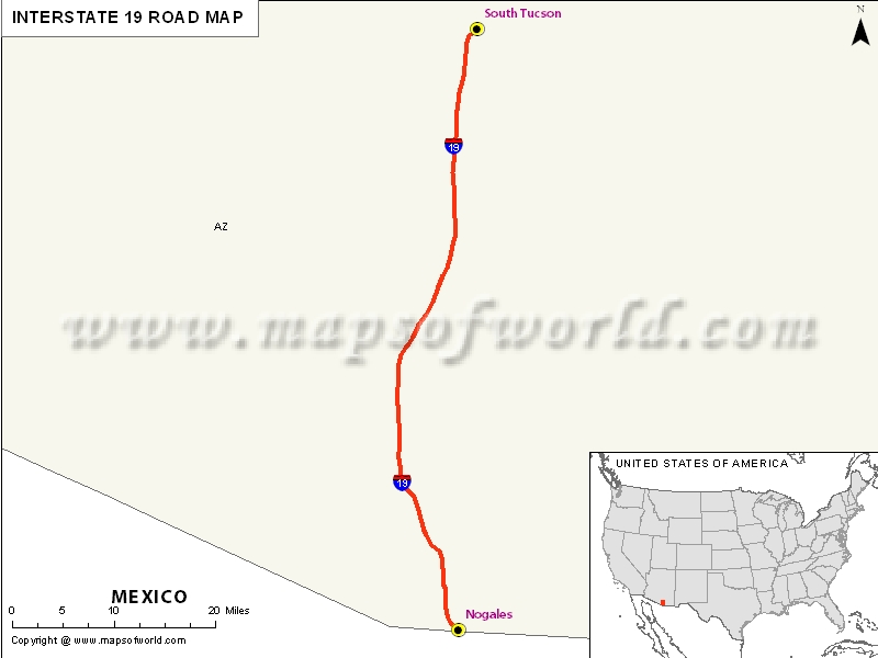
Interstate 19, popularly abbreviated as I-19, is also situated within the US state of Arizona. The highway has a total length of above 63 miles and is the fourth-shortest primary Interstate Highway in the 48 contiguous states, out of which I-97 and I-86 lie on western side.
Serving as a vital corridor, the Interstate 19 Highway is short and acts as the fast route from Tucson and Phoenix to the Mexican border. It is also a unique portion of the United States section of the CANAMEX Corridor that stretches north from Mexico towards the Canadian province of Alberta.
Extent of I-19 Highway
Interstate 19 strecthed from Nogales, about 300 feet from the Mexican border to Tucson, located at I-10. It also travels through other cities including Rio Rico, Green Valley and Sahuarita.While Nogales has the southern terminus of I-19 in the West Crawford Street, the southbound travelers continue moving ahead to Nogales, Mexico and Sonora through the state-maintained roads, which further get connected with Mexico Federal Highway 5 either to the west or south of Nogales, Sonara.
States and cities along I-19 Highway
- Arizona: Tucson
Restaurants along Interstate-19 Highway
Here is a list of few great restaurants along Interstate-19 Highway:- Crab Trap I
- Karichimaka Restaurant
- El Zarape
- Pizza Pollis
- Bella Mia Ristorante
Attractions along I-19 Highway
Some of the renowned tourist attractions along I-19 Highway include:
- Tumacacori National Historical Park
- Pena Blanca Lake
- Desert Museum
- Titan Missile Natl Historical Landmark
Route of Interstate Highway No.19 |
| State | Entry Point | Exit Point | Length |
|---|---|---|---|
| Arizona | Nogales, AZ | Tucson, AZ | 101.84 km (63.28 mi) |
| Total Length | 101.84 km (63.28 mi) |


